
post by Eric
Southeast Arizona has some great hiking opportunities – but only if you love sunshine and mountains.
My mom lives in Sierra Vista, a small town southeast of Tucson. The surrounding flat scrub desert is punctuated by relatively tall mountain ranges called “sky islands.” These forested enclaves, rich in animal and plant life, are laced with trails. And the views! You don’t have to climb far before you can see for miles.
I love visiting my mom. We get along great and never lack for something to talk about. She’s turning 90 this summer, living independently, and doing great. I check in with her on her health and finances, and we talk about end-of-life issues. What a relief to be able to talk about those things with her.
 |
| Mom and me in the ridiculous little convertible I got talked into renting (for the same price as the compact car I had reserved). That was a one and done. The darn thing didn't do very well on forest service roads! |
When I visit, I usually have a variety of things I want to do, including birdwatching (it’s a birding hotspot) and being a tourist (Shootout at OK Corral is in nearby Tombstone), but if the weather’s nice (and it usually is), the “sky islands” call me. So, between visiting my mom and the hiking, I don’t have time for much else.
Here are four hikes I did on a recent week-long trip:

Tumamoc Hill: A Paved Break Before Hitting the Pavement
I selected this “trail” randomly from internet list of top Tucson trails. After a day of flying, I spent the night in Tucson and wanted a quick hike before driving down to Mom’s.
At the edge of the Tucson urban area, Tumamoc Hill offers a 3.1-mile, all-paved, out-and-back hike from a city street up to the top of a butte in an 860-acre ecological reserve. The gradient starts gentle but gets steeper, with a flat spot about halfway on which sit some research-related buildings.
 |
| One of the aims of the preserve is to study the plant life, like the saguaro cactus. |
While there on a mid-morning Tuesday I saw at least 50 people. It must be crazy during popular times. But the path is wide, so I never felt crowded. The population was diverse, from Patagonia-clad hikers to look-your-best-all-dressed-up walkers to weight-vest-wearing gym rats.
 |
| Start of the hike. |
The views were nice, and the trail had good interpretive signs, mainly about the plants and animals. All-in-all, it was pleasant, but I kept looking longingly at some dirt trails on the next hill over. From their layout, I assume they are mountain bike trails, and I did see a biker or two. Why am I so drawn to dirt trails?
 |
| Tumamoc Hill Trail |
 |
| Carr Peak from Miller Canyon |
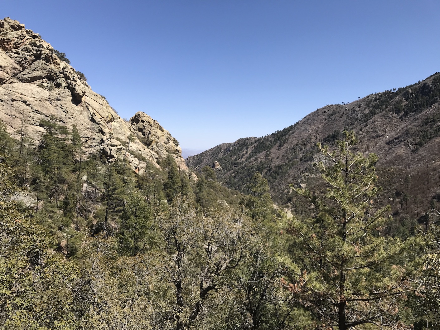
Carr Peak via Miller Canyon: An Accidental Summit
I didn’t intend to summit Carr Peak. For my first big hike, I planned a medium-distance hike in the Huachuca Mountains just west of Sierra Vista while getting used to the elevation. (Sierra Vista sits at about 4,600 feet.) The southern part of the Arizona Trail winds through these mountains, following the range’s crest. I planned to hike up Miller Canyon to the crest, take a snack break, then head down.
I hiked up Miller Canyon Trail. Like many Huachuca canyons, the area is forested and attracts a lot of birdlife. I ran into a birding group early on and was tempted to stop, but the trail called. I figured I could birdwatch on the return. The trail climbed gradually, paralleling Miller Creek, which was mostly dry with some pools higher up. The trail grew steeper, and I slowed as I began to feel the elevation.
 |
| The upper part of Miller Canyon is rocky and forested. |
I finally met the Arizona Trail at the crest and looked for a place to eat my snack. While poking around I saw a peak to the northeast that wasn’t far with a trail that ran along its base. I figured I could follow that trail and scramble to the top of the peak. What the heck, I thought, I might as well eat my snack on that little no-name peak. I had some momentum.
As I hiked, I felt refreshed from my poking around. The trail gradient wasn’t too steep, and the views got better. I made good time. At the base of the peak, I found a spur trail with a sign that said “Carr Peak.” That’s Carr Peak?! I thought. I wasn’t quite sure. Maybe the trail went beyond this peak.
I took the spur trail, which led to the top of that no-name peak, which was, in fact, Carr Peak (9,229 feet). Son of a gun! I grinned, knowing I had hiked to the second-highest peak in the Huachuca Mountains by accident. I aired out my feet and had a Clif bar while enjoying the views. Just to the south was Miller Peak, the highest in the Huachucas. Earlier I had passed a side trail to it, deciding it was too far. I began to rethink what was possible.
 |
| My feet enjoying the view of Sierra Vista from Carr Peak. |
While resting, I heard a loud swish. I wondered if someone was coming up the trail but saw no one. Then I heard it again and looked up. A swift! We have swallows in Alaska but no swifts. I pulled out my binoculars, but it was moving too fast to ID. I also saw a bluebird singing from a snag.
I headed down, feeling good, even running a little. I never did stop to do any more birding. It just felt good to move. I made it back to the car about 11 miles later, feeling satisfied. I had done more than I thought I could do.
 |
| Carr Peak via Miller Canyon Trail |
 |
| Miller Peak Miller Peak via the Crest Trail: A Case for Extra Water |
Two days later I decided to hike to Miller Peak along the Crest Trail from Montezuma Pass. I felt confident. This hike would be a tad shorter and started at a higher elevation. I brought plenty of water, as there would be none along the crest. But I should have brought more.
A trail description (either AllTrails or Hiking Project) said the first two miles were steep then got more gradual. Lies! There were a few short gradual sections, but this hike just kept climbing.
The views were awesome from the get-go and kept getting better. From this end of the Huachucas you get a great view of Mexico. It doesn’t look any different over there, but you can see part of the border wall, which looks insignificant from afar.
 |
| The thin black line running left-to-right at an angle is the border wall. The greenery of the San Pedro River runs across the middle of the photo. |
Nearing Miller Peak, the trail had many steep switchbacks. Quite a grunt! But I had momentum. Eventually, I got to the peak’s spur trail and soon was on top! The views were again spectacular. Carr Peak had been a flat gravel summit, but Miller Peak (9,470 feet) was a bit rockier and had a flat concrete area. It used to house a lookout tower.
 |
| Parts of the trail had a significant drop-off. |
While on top I took a couple of selfies. I sent one with a mountain background to Corrine. I sent one with Sierra Vista in the background to my mom. Mom responded with “Different background! Very interesting! Looks quite desolate....” I texted her that it was her town in the background. “Eek!” she responded. She later said Sierra Vista didn’t seem so barren from in town.
 |
| Carr Peak in the background |
 |
| Sierra Vista in the background |
On my way down I passed a few backpackers coming the other way. A woman said she was headed to Bathtub Springs. That rang a bell. At the headwaters of Miller Creek two days earlier I had seen some backpackers shouldering their packs at a flat spot with an old-style bathtub. Must be it, I thought. I talked with another backpacker about how dry the country was in this area and the need to carry plenty of water.
One person I passed didn’t seem to be either a dayhiker or backpacker. He wore camo clothes, and his full-length pants were pulled up above his knees to stay cool. He carried a huge camo daypack that seemed packed full. He moved slowly but steadily. I stepped to the side, we exchanged brief pleasantries, and after he passed I started down the trail. Then he said something to me. I stopped and looked back. “Water?” he asked. “Do you have water for me?” I was taken aback and confused. He had said it as though I was supposed to have offered him water. “Sorry, but I don’t have much left.” He said OK, and we went on our ways.
 |
| An old burn near the top of Miller Peak. |
That encounter got me thinking. Was he a border crosser? Maybe a mule, carrying drugs or other contraband? Or maybe just someone looking for work? He had been polite and given off a gentle vibe, so I didn’t think much about it until after he had asked for water.
Then I started feeling kind of bad. The only water I had was in my daypack bladder, and I’m never quite sure how much is left. I had been reluctant to part with any since I had several miles left in my hike. But later it occurred to me that he might have really needed it. I probably would have given him some had asked me right away, but I was already moving down the trail when he asked. I had momentum.
I didn’t agonize over it, but I did ponder about whether it would have been right to give him water, since he might have been a mule. I decided that I since I didn’t know his story, I should have given him the benefit of doubt. I don’t hike near the border often, and I had never run into that situation before. I decided if I hike in a place where a similar situation might arise, I should carry a small bottle of water to give away. In retrospect, the guy wasn’t too far from Bathtub Spring, so he probably did fine.
 |
| Miller Peak via the Crest Trail |
 |
| Mount Wrightson |
Mount Wrightson: Another No-Intention Summit
I left Mom’s place Saturday morning with the intent to do a small hike in the Mount Wrightson area, just south of Tucson, while driving to that city. I had booked a hotel room and was catching an early-morning Sunday flight.
I had decided against a big hike. I wanted a leisurely morning with Mom, and I still need to get to Tucson and get ready for my flight the next day. All that would take time. I picked a couple of trails out of Madera Canyon and hoped to do one of them. Probably a 5-mile hike, max. After some delays, I finally got started on the hike at about 1:15pm.
Fortunately, I lucked out on a good parking spot at the end of the Madera Canyon Road. And when I started up Old Baldy Trail, I was feeling good. I had been warned that the trail was steep, but it was less steep than the trails I had done earlier in the week. I started fast and kept up the pace, passing many people who were coming down.

I immediately noticed a difference from the Tumamoc Trail. Everyone here had on typical hiking clothing, and all were friendly. Almost everyone greeted me and stepped out of my way before I had a chance to do the same. I was out-polited! The Tumamoc hikers were not unfriendly, but that trail had a city sidewalk vibe. Few people said hi or even made eye contact. Here I felt like I could stop to chat with almost everyone. Interesting difference.
But I didn’t stop to chat. I was on the move. When I got to the top of Old Baldy, I knew I had time to take the lower leg of the Super Trail, an alternate but longer way back to the trailhead.
However, a sign there said two routes to Mount Wrightson. From an earlier sign, I knew it was a 5-mile hike to the top. So, 10 miles roundtrip. I knew I had the ability, but did I have the time? I thought I had a Clif bar and headlamp in my pack but didn’t check. After all, I had eaten a Subway sandwich at the trailhead, and my phone has a flashlight app. I agonized over that decision for about five seconds and the charged up the short route to Mount Wrightson. I had momentum.
 |
| Nearing the top of Mount Wrightson. |
I kept going hard and fast, feeling good, passing a lot of people coming down. But no one was going up. Was this wise?
I slowed a bit on the steep switchbacks, but the summit kept getting closer. Finally, I got to the 0.9-mile spur trail. You’re darn-tootin’ I went for it! I got to the top in 2 hours, 15 minutes, plenty of time to beat the sunset back down.
Again, the views were astounding from the top. Gorgeous mountains and desert all around. I chatted with a nice fellow on top for about a half-hour, staying longer than I had intended. As I headed down, I started thinking about the longer route down, the Super Trail. Did I have the time? I would if I ran some of it. But earlier that week when I had tried running, a calf injury I thought had healed started bugging me. Maybe not such a good idea.
 |
| Just one portion of the 360-degree view from on top. |
I got to the bottom of the spur trail and looked at Super Trail. Go for it! I thought. I soon got to a place I could run. I tried it and felt OK. I made good time and traveled some new country. Awesome!
 |
| On the way down views, views, and more views! |
When I got to the next major trail junction I had to decide. Go back to the trailhead on the known, short route – Old Baldy, a little more than 2 miles – or the new-to-me longer route – lower Super Trail, about 4 miles. My debate lasted about two seconds. Super Trail. I had momentum.
More running followed – or speed-hiking when the trail got rough. I kept making good time and got to the trailhead before dark fell – tired and sore but pleased that I had done a nearly 14-mile figure eight loop in just over 5 hours.
Google Maps accurately led me to my hotel as the sun set. I got all my tasks done, settling for a quick Filet-o-Fish and fries for dinner, and got to bed at a halfway decent hour. I was happy and beat. Thankfully, I no longer had momentum.
 |
| Mount Wrightson hike |
No comments:
Post a Comment