Wednesday, August 4, 2021

South Dakota: How I Stayed Entertained While Corrine Suffered


Post by Eric 


Once Corrine decided to suffer through the Trans South Dakota bikepacking race, I had three simple jobs: Drop her off at the start, entertain myself for several days, and be at the finish before she did. 


The first part was easy, since Corrine made sure I got her to the start on time. The end was easy too, since I made sure to get to North Sioux City a couple of days ahead of time. In between was a little trickier, since I’m not crazy about constant travel or hotels, and I was a little dubious about what South Dakota had to offer, but I found lots of places to explore.


(The above photo is from some singletrack trails on the rim of Spearfish Canyon from the day before the start of the Trans South Dakota. Corrine took an easier ride that day for obvious reasons.)


Day 1: SPEARFISH 


I visited Wayne Alderman, an old college buddy, and his wife Marian. They live in Spearfish, close to the race start. They wanted to meet Corrine and were very curious about the concept of bikepacking races. We met Corrine and a couple of her “competitors” at Spearfish Canyon Lodge, about Mile 37 into the race. We weren’t allowed to help in any way, but I did give Corrine a hug and a kiss. Corrine and the other racers talked about how the race had gone so far, which gave Wayne and Marian a snapshot into what it was all about. They immediately became dot-watchers, keeping track of Corrine throughout the race. 


Wayne plays a tune on his mandolin while Marian (and I) listen. 

Later that day, Wayne and Marian showed me around Spearfish, which included a tour of the D.C. Booth Historic National Fish Hatchery & Archives. Some of the trout there are HUGE! I mean, like salmon sized! 


I forgot to take a photo, so I grabbed this one off the Internet. Those are trout!

Day 2: ANNIE CREEK AND ULTRAMARATHONERS


I was a little unsure about what to do or where to be. Corrine was nervous about the heat and a couple of 100-mile sections without water resupply. I wanted to be ready to go save her, if necessary, but I also wanted to have fun. I got a motel in Rapid City, on the eastern edge of the Black Hills. On the way from Spearfish, I drove by Annie Creek Trail, a notorious part of the Trans South Dakota with a bunch of hike-a-bike. Corrine was already past it, but I decided to check it out. 


I biked for a few miles but kept running into trail intersections and didn’t know for sure which way to go. So, I just guessed, riding and pushing farther back into the woods. The trail did have some hike-a-bike, but it wasn’t too bad. Finally, I came out on a subdivision. That kind of blew me away. Being from Alaska, I’m not used to heading deep into the woods and coming across a modern subdivision. I figured I had gone the wrong way, so I rode a bit of the subdivision roads and then turned around. (Later, I learned that was the Trans SD route! Not the wilderness I’m used to.)


A rocky (and pretty) part of the Annie Creek Trail.

After that I drove the roads that more or less paralleled the Mickelson Trail, which the Trans SD follows for about 40 miles. It would have been fun to bike part of it, but I didn’t have time. I stopped in a dinky town called Rochford to get something to drink. About the only thing open was a bar/restaurant with a bunch of people hanging around inside and out. The bar had bottled sodas, so I got one. 


As I walked back to my car, someone called out to me. A young couple had spied my T-shirt, from the Sluicebox 100, and were curious. They turned out to be Ryan and Emily Wanless, residents of Sioux Falls. Ryan had competed in the Iditarod Trail International to McGrath on foot and knew mutual friends. Ryan had signed up to go all the way to Nome this year, but COVID turned the race into a shortened out-and-back. Emily is also an ultrarunner. They knew about the Trans South Dakota and were eager to hear about Corrine when I told them she was competing in it. We talked for a bit, happy to have found someone in tiny Rochford who “got it” about ultramarathons. Small world!


Day 3: RAPID CITY AND BUZZARD'S ROOST 


I felt confident Corrine wouldn’t be calling me for a rescue, so I thought I could wander a bit from Rapid City. I checked out the Trail Forks website and found several trails and trail systems in the area. One new system, Buzzard’s Roost, was only about a half-hour from Rapid City and looked interesting. I headed out after breakfast. 


The system is on a fairly steep hill but is well-built with lots of switchbacks. I made my way to the top, which ends in a rocky outcrop with nice 360-degree views. I putzed around on the trails a bit, before heading back down, chatting with some cows on the way. I was glad to be finishing as the temps climbed into the 90s. 


The view from atop Buzzard's Roost.

Days 4 and 5: COWBOY HILL AND DINOSAURS


Staying in place for a couple of days allowed me to check out some nearby trails I found on the Trail Forks. Some visionaries in Rapid City long ago helped save big parts of two ridges right in town. Both now have extensive trail systems. I spent the first day biking around Cowboy Hill and on the Leonard Swanson Memorial Pathway, which follows a greenbelt through the middle of town along Rapid Creek. I had a great time and was out longer than I had planned. I got saddle sores from sweating so much. Temps were in the high 80s and low 90s. How can people live in that heat?!  (P.S. I also learned that marmots live on Cowboy Hill and that people down there call them rockchucks!)


Some of the trails in the Hanson-Larsen Memorial Park on Cowboy Hill. 


A particularly nice section of the Leonard Swanson Memorial Pathway. 

The second day I went running in the Skyline Wilderness Area on the other ridge. That was an odd mix of nice quiet trails, noisy trails right above a bustling part of town, and a kitschy private dinosaur park. Fortunately, through dumb luck I started with the kitsch and noise and ended up with the quiet. Then I drove east to Badlands National Park (where real dinosaur bones have been found) and did some fast-hiking on several of the developed trails in the park. Most were a little too crowded for my tastes, but it was fun to see features of the Badlands, all created by erosion. What a surreal place! I also saw some birds, but I was moving too fast to ID most of them (though I did see a blue grosbeak!). 


There be dinosaurs!

The surreal landscape of the Badlands. 


Day 6: BADLANDS AND NORTH SIOUX CITY


After spending the night in Wall, I went back to the Badlands. I drove the main road, stopping at all the roadside pullouts (including a stop to see some Badlands bighorn sheep) and then hiked most of the trails that I didn’t get to hike the day before. 


This time I went slower, since I knew the temps would be in the low 100sF. I did a bit of birdwatching, but I didn’t see that many. Still, it was good to be going slow. I was walking leisurely and still sweating up a storm! I couldn’t dawdle, though, since I had made reservations in North Sioux City starting that night to make sure I was at the finish well before Corrine got there. 


Feeling the heat on the Castle Trail of the Badlands. 


Day 7: MAKIN' BACON ON A BIKE


Once again, the Trail Forks app gave me some good info. Using it I found the Bacon Creek Park singletrack trail. One big loop about 6-7 miles long. I wasn’t expecting much, but it was a swoopy, well-maintained singletrack that was super fun on a bike. It had some tricky features (most of which I avoided) and even some views. I had a great time on the trails but was happy to finish after a couple of hours. Temps were rising and eastern South Dakota has higher humidity than in the west. 


I was going to go for a hike on yet another set of trails nearby, but I got lazy. Plus, Corrine did a big push of almost 150 miles that night. (She traveled at night to beat the heat.) She was figuring she might finish as early as 5 a.m. the next day, so I went to bed early. 


Bacon Creek Lake from the high point of the Bacon Creek Park singletrack trail.

Day 8: A BIG FINISH AND LOTS O' GREEN


Corrine texted me a few times in the night. She had only 75 miles to go, but most were hard miles (see her post here). She was struggling, but I would have done everything I could to avoid rescuing her that close to the end. Fortunately, she never asked. I drove out and cheered her on with about 8 miles to go. 


Corrine finished at 7:20 a.m., looking awesome and energetic! Since she was the last finisher, Joe and Tina Stiller, the race directors, didn’t have to wait for anyone else, so we all went out for breakfast. After we were done, Corrine wanted to nap for some reason! I went out for another trails exploration, another find on Trail Forks. 


Corrine poses with her finisher's medal while Joe Stiller takes a photo
at the end of the Trans South Dakota.

I went for a run on the trails at Stone State Park, just a few miles from our hotel. These were doubletrack trails, mostly in thick woods, much different than the dry, sparse forest on the west side of the state. Not many views, but interesting stuff on the trails, like green seeds the size of golf balls (walnuts, probably) and green beetles and ladybugs. I was happy to get out for a trail run, but the heat and humidity started ramping up, so I didn’t go long. 


Stone State Park in North Sioux City. Things were much greener - and more humid - on the
east side of South Dakota. 


All in all, I had a great time exploring while Corrine did the Trans South Dakota. I was delightfully surprised by all that South Dakota had to offer. I never ran out of things to do, and there was more exploring I could have done. 


Sunday, August 1, 2021

Trans South Dakota 2021

Post by Corrine

“F--k,” I yelled into the phone and then gave a little laugh. 

Eric chuckled uncertainly. I yelled the obscenity again, then told Eric that I had missed a turn and was going to have to backtrack 9 miles on the Mickelson Trail or get disqualified from the Trans South Dakota, a 714-mile bikepacking race I had entered. After 70 miles and 8,000 feet of climbing, this was not how I wanted to end my first day. 

After letting out my frustration, I got off the phone, biked back to where I missed the turn off, then turned back around and biked 7 miles back up the Mickelson Trail before setting up my tent at midnight. Despite my frustration, that little detour ended up being one of the easier challenges I had on the Trans South Dakota. 


Joe and Tina Stiller, proud South Dakota residents, devised the race to showcase their state. Starting in Beulah, Wyoming, just across the western border, the race crosses the Black Hills, the Badlands, and ranch and farm country before finishing in North Sioux City. Sites along the way include Mount Rushmore, Badlands National Park, the state capitol building, and the Corn Palace. You also get a chance to packraft 5 miles down the Missouri River. Racers also had shorter options of 60 miles, through the Black Hills, and 355 miles, to the Missouri River. 

Joe and Tina Stiller - Race directors of the Trans South Dakota

The race is one of the few bikepacking races to charge a fee, but it was worth it. Among other things, the fee pays for use of a packraft for the river crossing, so you don’t have to carry one the whole race, and motorboat support while on the river. I had signed up to do the race in 2020 but had to delay one year due to COVID. I felt fortunate I got to do it, since Joe and Tina have decided to stop running the race. It takes up a lot of time, and they have other adventures they want to do. 


A TOUGH RACE

So, how hard is a bike race across South Dakota? Isn’t it mostly flat and easy? No! It’s much harder than you might think! The biking wasn’t that difficult. The route had only about 30 miles of singletrack. Most of the rest was on gravel roads. There was some hike-a-bike, but it was almost all rideable. 


The biggest challenge was the heat. This year was hot even by South Dakota standards. Almost every day the temperature rose above 100F. And then there was the 10-25 mph headwind from the south to southeast for almost the entire race. Also, after the first day, finding water was a challenge. I had to go a couple of 100-mile stretches with no water resupply, so I had to carry a lot on my bike. The Trans South Dakota ended up being one of the most challenging bikepacking races I’ve ever done. Half of the full-distance racers either dropped out or moved down to the 355-mile distance. 


DAY 1: A FLAT AND A BACKTRACK

But it was wonderful, too! The first day was my favorite. Riding through the Black Hills with a lot of singletrack and varying terrain was awesome. But you had to pay attention to your GPX as there were many intersections. I wasn’t the only rider to get “bonus mileage.” That first day I kept leapfrogging with two other riders – Brian (from Kasilof, Alaska!) and George. They would pass me, but then take a wrong turn. I kept having to show them the correct way to go.

Wildflowers in full bloom in the Black Hills

George and Brian leading the way

Section of hike-a-bike on Annie Creek Road

I stayed with those guys through Spearfish Canyon and a gold mine until we got a nice long downhill on good gravel. I was going about 30 mph when I hit a big rock and immediately could feel something wrong. I stopped and, yep, I had a flat back tire. 

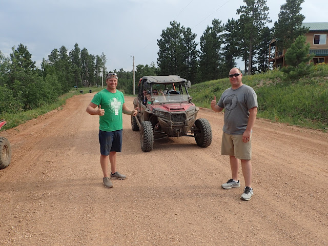
Several other bikers passed me as I pumped and spun the tire, seeing if my sealant would seal the hole. No such luck. Sarah, another woman doing the full distance, stopped but she wasn’t sure how to help, so she continued. A family on ATVs stopped and helped me pump up the tire, but it kept losing air. Finally, I realized I would have to put in a plug, which I had never done before. The ATVers gave me moral support and helped with pumping after I plugged the hole. We held our breath and lo and behold, it held! They said that if I had more problems I could just spend the night with them, back up the road about half-mile. I thanked them and headed on my way. (That plug held the rest of the race!)

Friendly ATV'ers who stopped to help

I had lost about an hour with my flat, so I bombed downhill pursuing the other racers all the way to Lead (pronounced Leed). I got supplies and water and ate some dinner then headed out about 7:30 p.m. toward the Mickelson Trail, a 220-mile rail-trail with easy grades and good gravel. While trying to find the trail I could see on my GPS device that I was a little off. But I couldn’t see any other trail. I tried to call race director Joe but just got his voice mail, so I left a message and continued. After about a mile, I saw a place to get on the Mickelson Trail, so I entered it and kept going. 

Great gravel on the Mickelson Trail

After 9 miles, it was getting dark, and I was thinking about camping. Signs along the trail said, “No camping” and I knew we had to ride the Mickelson for about 40 miles. I tried calling Joe again, as I thought he might know if I could camp just off the trail. That’s when I found out I had missed the first mile of trail! I had a choice. I could continue and be officially disqualified, or I could backtrack to ride that section of trail. That’s when I called Eric. I knew I would backtrack, but I just needed to vent. Fortunately, they were pretty easy miles, but not a great way to end Day 1. But Joe did give me tips on where to camp. 

DAY 2: RUSHMORE AND AN INVITE

I got up at 4 a.m. with the temperature hovering around 45F. The previous day the highs had been in the 90s, so I welcomed some cooler temps. But soon I had a 20-mile downhill into a valley where the temperature bottomed out at 38F. Brrr! But that was the only time I was cold the entire race. The sun soon came up, I started climbing, and I was again hot and sweaty.

Largest carved Smokey the Bear in Hill City

After breakfast in Hill City, I biked to Mount Rushmore, where racers had to take a selfie and post on social media. (Posting a few selfies is a fun quirk of the race.) Rushmore was very crowded, so I took my photo and quickly moved on. Next was a long climb on the popular “Pigtail Highway,” so named because of several loop de loops. It was a long, hot grind made worse by all the traffic. I finally made the top and bombed downhill to Hermosa. At about 4 p.m. I stopped at a convenience store for some ice cream and a burger before heading out onto the Pine Ridge Reservation and into wide-open ranching country. The Black Hills mountains were behind me. I biked into a hot headwind, something I had to get used to in the days that followed. 

Very crowded at Mt. Rushmore


One of the hundreds of motorcyclists that passed me on the "Pigtail Hwy". We went through several tunnels

Birdseye view of a "pigtail" on the "Pigtail Hwy" - taken off the internet

As it was getting dark, a car stopped, and a woman got out. She asked where I was camping that night and I told her Sage Creek Campground, still many miles away. She offered to let me camp in her yard just 4 miles ahead. I was tired, so I took her up on her offer, deciding to get up early the next day. That first offer turned into a shower, a bed, and some ice cream! That’s South Dakota hospitality! 


We had a great talk. She and her husband raise and breed cattle. It’s a hard but good life that she enjoys. Her husband, still out mowing hay, didn’t come home until after I was asleep. As we talked, I found out that her husband’s brother had been stationed at Eielson Air Force Base outside Fairbanks and she had been there several times. Small world! I love these random interactions that happen when bikepacking. She offered to make coffee at 5:30 a.m. I thanked her, but I wanted an even earlier start to avoid some of the heat. 

Jody Lehrkamp who offered to let me stay at her ranch

DAYS 3 AND 4: BADLANDS AND A CHANGE OF PLANS

The next morning, I was biking by 4 a.m. and made Badlands National Park by dawn, where I took a race selfie at the sign. 


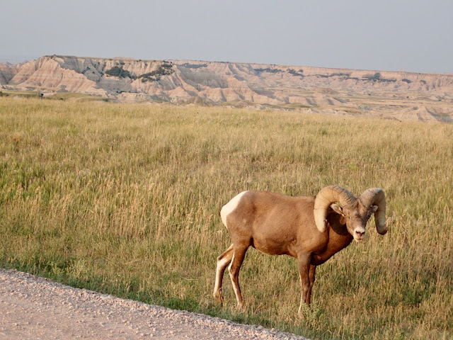
The road we were supposed to take was blocked with a “Closed” sign. Uncertain, I continued. After several miles, a ranger came by and said I shouldn’t be on the road because they were going to be dumping gravel on it. I was only 5 miles from the end, so he let me continue. When I got to Wall, I called Joe to tell him about the closed road so he could reroute the racers behind me. I felt fortunate I got to ride in the erosion-created Badlands, which were otherworldly.  I also had the chance to see Bighorn sheep and prairie dogs up close and personal.

Badlands at dawn

Bighorn sheep grazing by the road

Prairie Dog Town

I restocked in Wall and continued. I had to walk hills that I should have been able to ride because it was so hot. I took breaks at any shade I found. I started seriously considering riding at night. I hadn’t planned on doing that, but the days were just so hot. Also, the wind was much calmer at night. 


I made it to Philip around 3 p.m. after riding only 80 miles. I got a hotel and considered sleeping a few hours before heading out to ride at night but quickly concluded that I was too smashed. Instead, I rested a full 36 hours so I could start riding the following night. The only way I could finish, I had decided, was to ride at night.

Main Street in Philip, SD

DAY/NIGHT 5: NIGHT RIDING AND THE RIVER

I headed out the next evening around 5 p.m. and rode 100 miles to get to the halfway point on the Missouri River. Night riding was so much more pleasant! The temps were 65-70F vs 100F. I listened to crickets and cicadas and saw skunk and deer and owls and other night creatures. I didn’t suffer like I did during the day. When I started feeling sleepy, I took a caffeine pill and listened to books, podcasts, or music on my phone.

Sun starting to go down as temperatures start to drop, too

Burrowing owl that I scared up.  It's trying to hide from me.  I saw many of these on the trail

I got to the halfway checkpoint on the Missouri River at 4:45 a.m. I was supposed to float 5 miles of the river, but a strong headwind made the water really choppy. The day prior, racers took 5 hours to paddle those 5 miles. I didn’t feel comfortable paddling in those conditions, and I knew the effort would exhaust me. I discussed it with Joe, who was there to assist racers down the river. He said I could take a 12-hour penalty and then bike back to the bridge and into nearby Pierre, the state capital, to get back on course. I took that option. I was disappointed that I didn’t get to do the bikerafting float, but my main goal was to finish the race. I biked into Pierre to get a hotel room and rest.

Crossing the Missouri River by bike on the bridge instead of bikerafting

Pierre (pronounced pier) state capitol building

DAY/NIGHT 6: PEDALING AND MORE PEDALING

I left Pierre at 5 p.m. with a temperature of 105! I filled my water bottles with ice and soaked my shirt in cold water. It took only 17 minutes for my shirt to be bone dry again. That’s how hot and windy it was! But the temperature dropped at sunset. 


This section was a long grind, including a 100-mile stretch with no reliable water. But riding at night made a huge difference. I biked 130 miles, arriving in Wessington Springs about 10 a.m. the next day. I had breakfast, got a hotel room, slept a few hours, and then got up to ride another night.

I passed through this wind farm at night. I could see the lights from the turbines for miles and miles but couldn't figure out what it was until I was finally right there. Almost full moon made for nice night riding.


Old abandoned church on the way to Wessington Springs

More abandoned buildings.  I wondered about the people who lived here and why they left.


DAY/NIGHT 6: CORN PALACE AND MORE PEDALING

I got to Mitchell at 1:15 a.m. and had my race-required photo taken by a friend of the race directors in front of the Corn Palace. After a quick break, I continued, trying to make as many miles as I could before sunrise at about 6 a.m. When the sun came up, I started flagging. I had breakfast in Menno and continued on. It took me forever to go the final 30 miles to tiny Viborg, which I finally reached at 2 p.m. after almost 150 miles of riding. 

Required photo at the Corn Palace

Viborg doesn’t have a hotel, but I called some friends of the race directors who let me sleep in the air-conditioned community center and even brought me a towel so I could take a shower. I was so grateful for that wonderful South Dakota hospitality! After three hours of sleep, I was ready for the final push to the finish. I only had 75 miles left. How hard could it be?

Lynn and Gloria of Viborg let me into the air conditioned Community Center so I could shower and sleep

DAY/NIGHT 7: MISERY AND SUCCESS

That last night almost broke me. The first 15 miles were fine. A rancher stopped to talk when I stopped to adjust my bike. He begged me to let him drive me to the finish, but I told him I couldn’t do that! It’s a good thing he hadn’t come by a little later. 

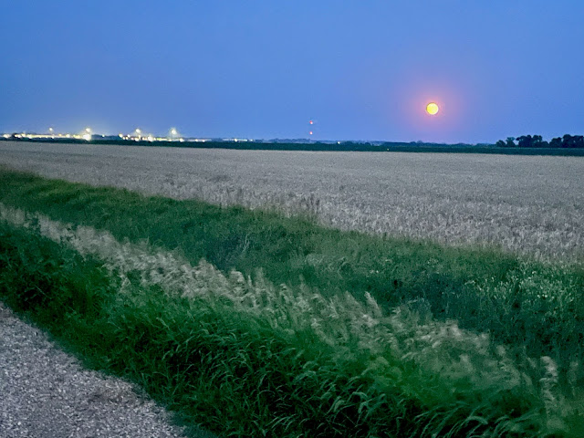
Full moon rising above Beresford

After a quick stop to refuel at Beresford, everything went south. There were lots of steep rolling hills that sapped my energy. Then I had to go down a closed road that required me carrying my bike down a steep drop off, then bushwhacking through dense foliage for a mile until I finally came to a bad but bikeable backroad. Then more steep rollers. I was so tired I couldn’t bike anything more than a 5% grade and these were all 9-10% grade.

Almost done with the rough trail in the dark

Then as I was switching gears, my front cable snapped. Really? There was no way I could fix that. Luckily, I was in my smallest chain ring up front and still had 10 gears on the back. I hoped nothing else would go wrong. Then it started raining. Ugh! I put on my rain jacket and kept moving. I wanted to quit, but I couldn’t quit this close to the finish, could I?!

Snapped cable

Since it was dark, I had no sense of the terrain around me. Would I keep going up and down? Was I getting anywhere? I was so tired and was moving so slowly. The roads were so bad and soft that I had to go downhill slowly, too. At the top of the next hill, I finally stopped to take a break. I was so tired, and my stomach was rebelling again. At least the rain had been brief.

I was feeling sorry for myself and may have shed a few tears. I texted Eric and told him that I didn’t know if I could finish. It would probably take me another six tortuous hours to go the last 30 miles. He, of course, told me I was doing great and that soon the terrain would level out. Actually, I was at the top of the last hill and just didn’t know it. When I descended that hill, the terrain got much flatter, and I was finally able to start moving faster.

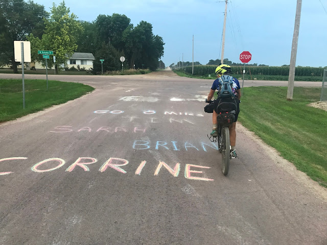
Only 8 miles left.  I'm pretty sure I can finish. Eric came out to cheer me on.

I was able to spin out the last miles and finish at 7:20 a.m. for a race time of a little under seven days total. I was so happy to be done and so happy that I finished! Several times I had considered dropping out or just finishing the 355-mile race. I entered this race to see and experience South Dakota and to challenge myself. I definitely did both! 

6 days, 23 hours and 20 minutes - I did it!

So, what did I learn from completing this ride?

1) I don’t do well with heat and have a hard time biking in it. (Although I already knew that.)

2) I enjoy riding at night more than I thought I would. 

3) No matter how many times I would scare up a bird or skunk or deer at night, it would always make me squeal! You think I would get used to that.

4) South Dakota has some incredibly beautiful areas. I had no idea.

5) Rural South Dakotans are incredibly friendly and helpful people. Even though I’m sure that most of the people I met were polar opposites politically from me, we were able to connect one-on-one as human beings. I love these interactions! I think because I was biking alone, I probably met more people.

6) Joe and Tina Stiller are amazing race directors and people. I’m so glad to have met them. They put on an amazing race. Thank you, Joe and Tina! 

Stats:

Time:  6 days, 23 hours and 20 minutes

Total Distance: 745.2 miles

Total Elevation Gain: 28,789 feet