
post by Corrine
I wasn't sure what to do.
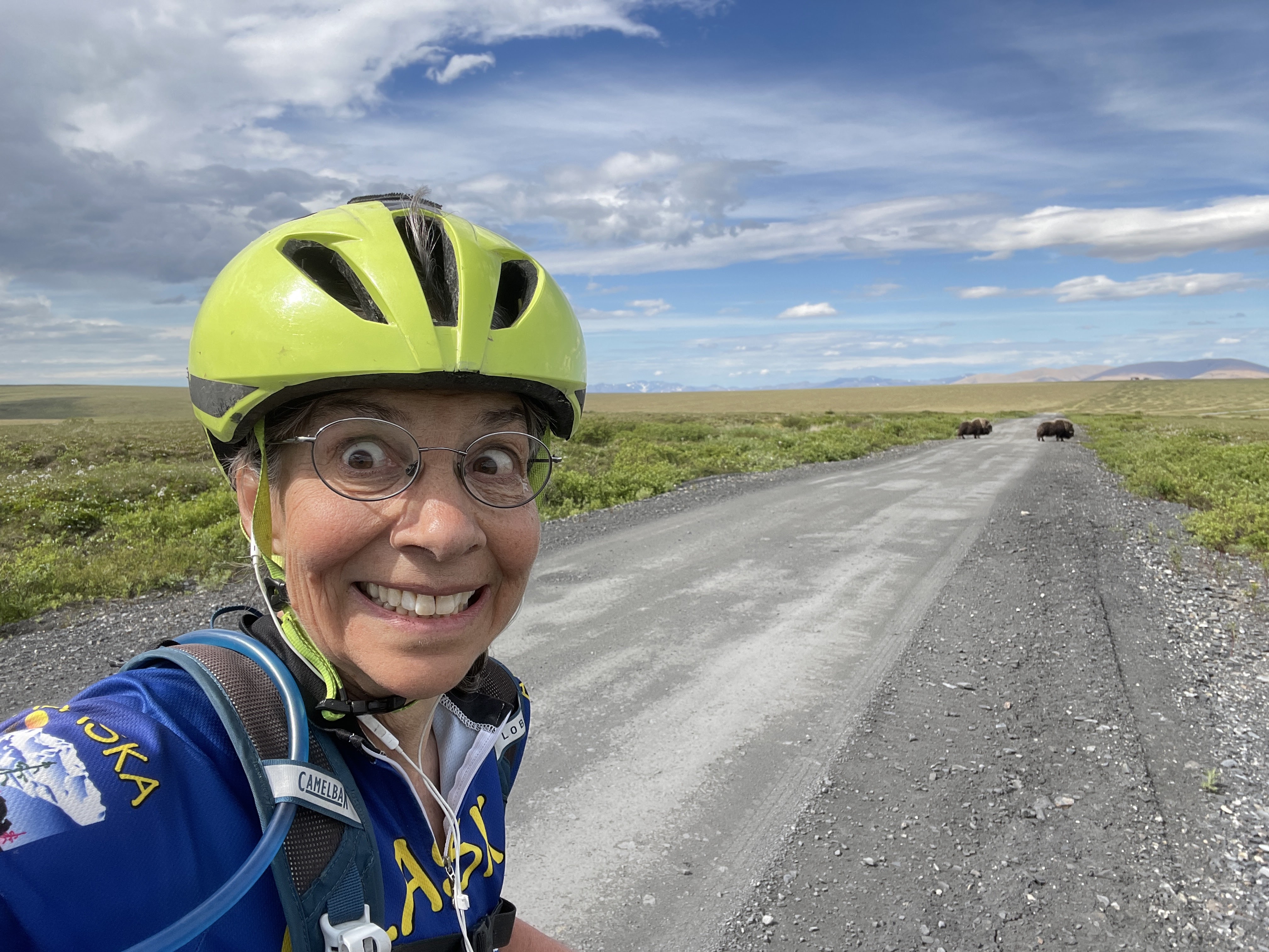
I was biking the final few downhill miles into the village of Teller when I looked ahead to the left. What was that big, brown thing on the side of the road? A rock? But it started moving. Holy Cow! Or maybe I should say Holy Ox!
Two musk oxen were grazing just off the road. I’d been wanting to see some up close, but this was almost too close! Then they decided to walk out on the road. I slammed on my brakes.
How do you deal with musk oxen? We don’t have a lot of experience with that in Fairbanks. Would they mosey along? Would they charge if I got to close?
I backed up a bit and took some photos. I waited. I waited some more. They weren’t moving. I blew my whistle, but the musk oxen just ignored me. Was it safe to pass even though one was on each side of the road? I knew Eric should be along soon with the rental truck. I decided to wait for a bit.
After about 15 minutes, Eric arrived and gave me and my bike a short ride past the musk oxen. The rest of ride, just a couple of miles, was much less exciting, though I did get a great view of Teller. A few minutes later I finished, having ridden just over 70 miles from Nome to Teller.
 |
| Teller on the spit |

Nome is best known for being the finish line of the Iditarod Trail Sled Dog Race. So, why visit in summer? Not for the weather. It is usually cool, rainy, and windy. And Nome is not exactly a tourist hot spot. It doesn’t have much in the way of tourist infrastructure or information, at least not for active, outdoor tourism. It has almost no established, signed public trails, road waysides, or public campgrounds.
And Nome is not known for its fine dining. Eric and I thought the food was just adequate, but the meals were expensive. The food at one restaurant, Pingo’s, looked and smelled delicious, but the restaurant was open only until 3 p.m. and had little seating. We waited for a bit and finally had to ask before being told it would be a long wait. Ah well. It definitely felt like a frontier town.
And yet we decided to spend a long Independence Day weekend exploring the town and the area. Why? Several reasons.
300 MILES OF ROADS TO EXPLORE

The main reason I wanted to come to Nome was to bike all three major gravel roads leading out of Nome. Each is over 70 miles long. I had seen photos from when Lael Wilcox biked all the roads in Alaska. And a friend, Kim, had biked there a few years earlier. From those accounts, I put it on my bucket list. Eric wasn’t interested in biking that much (I biked 235 miles in three days), but he was curious to explore the area. He had been to Nome briefly years before while covering the Iditarod Sled Dog Race but had never been there in summer. And being a bit of a birder, he knew there were some interesting birds to see in that area. Eric would drive the rental truck, allowing me to bike each road one way, and he would hike, bike, or bird along the way.

The three main roads out of Nome head in three different directions. The Nome-Teller Highway leads northwest to Teller, the Nome-Taylor Highway (aka Kougarok Road) heads north through the Kigluaik mountains, and the Nome-Council Highway heads east towards Council. All have unique features, are remote, and have beautiful scenery. While officially named highways, the roads are all gravel. And they are rough and slow for driving (expect to average about 30 mph) but are great for biking, either on a mountain bike or gravel bike.

Kougarok Road


I biked the Kougarok Road first. It gently climbs for the first 20 miles then has rolling hills as it turns east then north as it works its way around the Kigluaik Mountains (the Kigs). At about mile 55, it slowly descends for another 30 miles to the Kougarok River. I didn’t bike to the end of this road, missing the last 15 miles, since Eric and I wanted to bike to Pilgrim Hot Springs and back, before heading back to Nome. And the last bit of the Kougarok Road is less spectacular with mostly open tundra and ponds and willows.
This road has the only official BLM campground on the road system, located at Salmon Lake at mile 35. It’s a beautiful spot with six free primitive campsites. I stopped there for lunch during my bike ride. Pilgrim Hot Springs is on a side road off this road (more on that below). The hot springs also has a campground.
 |
| Salmon Lake |
Nome-Teller Highway

The Nome-Teller Highway (officially the Bob Blodgett Nome-Teller Memorial Highway) surprised me the most. I thought it would be mostly flat, but it actually had the most accumulated climbing. Lots of steep ups and downs. Lot of river crossings on bridges. Beautiful views of the Kigs to the east, especially from the high point before the last 10 mile drop to the village of Teller. Teller is a small Inupiat village of around 200 people on Grantley Harbor just off the Bering Sea. There are no services there, so after Eric picked me up, we just turned around and drove back to Nome.


Nome-Council Highway


The Nome-Council Highway has the highest point of the three roads (Skookum Pass at 1300 feet) even though it has, by far, the least amount of overall elevation gain. After looking at the weather and windy.com, I had Eric drop me off at Council and I biked back so I could have a nice tailwind for the last 30 miles along the Norton Sound. I made excellent progress the second half of this ride. Eric had his best hiking at Skookum Pass.
 |
| Starting my ride back to Nome from Council |
I had hoped to stop at the Safety Roadhouse (last checkpoint of the Iditarod) just 20 miles out of Nome and get a burger, but it is closed on Mondays, the day I was biking there! Still, it was fun to bike the road back to town, thinking of all my friends who have walked or biked the Iditarod Trail Invitational on this same last stretch of highway into Nome. I can’t begin to imagine how they must have felt getting to the Safety Roadhouse, knowing they were almost done.
 |
| At Skookum Pass |
 |
| Safety Roadhouse - Last checkpoint for the Iditarod Sled Dog Race |
HISTORY
 |
| Dredge |
Nome had a short but intense gold mining history. There are still active mines in the mountains and people still suction dredge on the beaches. Old artifacts, long since discarded, lay around in many places, even far out the roads, and are interesting to see. And, of course, the Iditarod Sled Dog Race ends under the burled arch in Nome on 2nd Street every March. The town is a happening place that week! And the Iditarod Trail Invitational racers finish at the same spot, though with much less fanfare.
 |
| Train to Nowhere in Solomon |
 |
| Burled arch finish line for the Iditarod |
WILDLIFE VIEWING
Nome and the surrounding area abound in wildlife, including reindeer, bears, moose, wolves, lynx, fox and of course, musk oxen, the unofficial ambassadors of Nome. Often, they hang out right in town. We saw several musk oxen, including my close-up encounter on the Nome-Teller Highway, and a fox on the Kougarok Road. Eric saw a moose and I saw a penned-in reindeer, but we saw less wildlife than I expected. We did see lots and lots of snowshoe hares on a short stretch of Kogarauk Road. We read later that they lick minerals off the road.

BIRDING

 |
| Long-tailed jaeger just standing on the road |
The Nome area is a birding paradise, especially around the time of the spring migration. We didn’t really go birding but were amazed by how much incidental birdlife we saw. Long-tailed jaegers, Lapland longspurs, golden plovers, whimbrels, red-necked loons, phalaropes, plovers and many more. We had hoped to catch a glimpse of a bluethroat but didn’t get lucky enough to see one. Eric had thought he would do a bit more birding while in Nome, but he ended up being too busy with other stuff.
HOT SPRINGS

About 53 miles out the Kougarok Road there is an 8-mile side road to Pilgrim Hot Springs. At the site, besides a rustic pool heated by the springs, there are buildings of a historic Catholic orphanage. Almost all the occupants of the orphanage died in the Spanish Flu of 1918. The area is now owned by a group jointly owned by several different Native interests. We biked the rugged road, which includes a decent climb, to soak in the hot springs. It was well worth the trip, but the road is very rough, and you definitely need a high clearance vehicle if you are going to drive it. The hot springs are in a beautiful setting. We got the chance to talk to one of the managers who told us about all the improvements they are working on to make this more of a destination. Right now, it has a few cabins and a campground for those that want to stay overnight, although we just soaked and then biked back to our truck at the Kougarok Road. If we had wanted to spend the night, we would have tried to rent a cabin.
 |
| There were a few puddles and we did get wet feet! |
 |
| The church at the orphanage |
SOLITUDE

The roads leading out of Nome are sparsely traveled. On each day, once I was out of the town proper, less than 20 cars passed me by. I’m sure it’s busier during hunting season, but it was amazing to be out there biking alone through mostly untamed land. Yes, there were signs of humans but also miles of open vistas, mountains, and streams. If you want a wilderness experience while being on roads, this is the place for you. We were there at prime wildflower time. Kougarok Road had the most varied wildflowers although all the high tundra areas were a bloom with flowers.


HIKING


Eric spent a bit of time online and at the visitor’s center looking for places to hike. He didn’t find much, other than several mentions of roads and trails up and around Anvil Mountain on the north edge of Nome. Only a couple of trails were on the popular apps. One or two websites mentioned a hike on the Kougarok Road up Dorothy Creek to a falls, but the creek isn’t signed where it crosses the road and the hiking looks brushy. Eric decided on an alpine hike a few miles before Salmon Lake. It wasn’t spectacular, but the hiking was nice. If he had had better information and more time, he could have reached a high point by going up another ridge. Other places farther along that road looked nice for hiking.
He did three hikes along the Nome-Teller Highway, with the second, at about mile 40 or so being the best. But the best hike he did was from the Skookum Pass parking area on the Nome-Council Road, which offered a couple of options, one to a high point to the west, and to the east a ridge with a rock outcropping at the end. He did both and enjoyed nice views and a good breeze to keep the bugs at bay the whole time.


WEATHER


 |
| This was the worst weather we had all weekend and it blew right past us |
I would not plan a trip to Nome based on weather, but we got extremely lucky! I was prepared for rain and cool temperatures, but we had five days with sunny to partly cloudy skies and highs in the mid 60’s Fahrenheit. And we had no rain except a little the last morning while we were still sleeping in our hotel room. We also had winds that topped out at only 15 mph. I planned my days based on taking advantage of the wind, and I was mostly successful. This was very unusual weather. If you go, don’t expect the same. Be prepared for rain and wind!
 |
| We got so lucky! Don't expect weather like this. |
A RUSTIC EXPERIENCE
There are plenty of reasons for heading to Nome in the summer, but you must be willing to put up with a rustic experience. Don’t expect to be treated like a typical tourist. This isn’t a community that will coddle you. If you’re up for that, and you want to see a northern tundra-centric, coastal area, consider Nome for your next summer adventure. I’m glad we did.
