Tuesday, August 25, 2020

Biking the Denali Highway


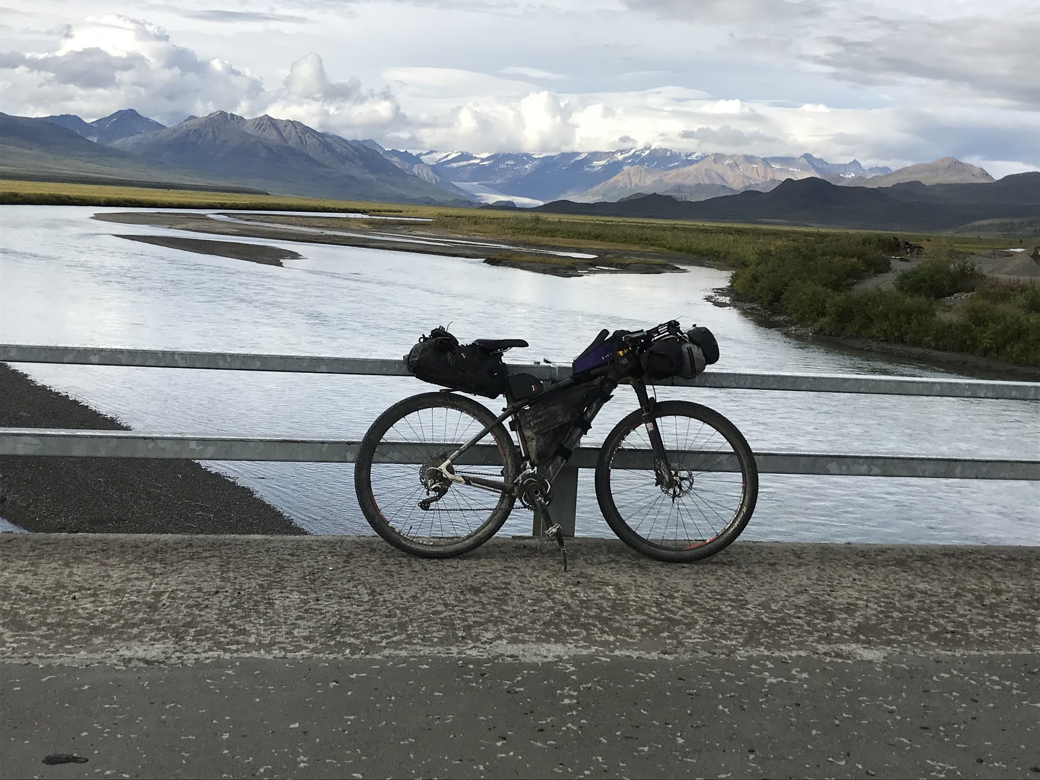
I love the Denali Highway.  Big open vistas, mountains, glaciers, good gravel and usually not much traffic.

The weather looked to be good for the weekend.  Even though I was tired and should have stayed home, I decided to do another trip.  I wanted to get out while the weather was still good and the Denali Highway was calling my name. I would go alone since Eric already had plans.  I really enjoy solo time in the wilderness so I was perfectly fine with this.  In addition, it really wouldn't be wilderness as hunting season had started and there were sure to be lots of hunters on the Denali Highway on a nice weekend.

I snagged a campsite in Denali National Park for Friday night.  I packed and had everything in my car so that I could head down right from work. I made it to the Savage River Campground with time for dinner and a hike before bedtime.

Evening hike along the Savage River 

I was up and moving Saturday morning by 5 AM as I had to drive 30 miles to Cantwell before starting my adventure. I had an ambitious plan to bike 100 miles to the top of Maclaren summit and camp, then turn around early Sunday morning and bike back.  Then drive home, unpack and get some sleep before work on Monday.  It would be a very full weekend. 

Early morning alpine glow on Denali

6 AM sunrise driving out of Denali National Park - It pays to get up early

Why did I want to go big like this?  I’m not training for anything at this point.  Was I trying to prove something?  Did I just want to see a lot of country or was it something more?

I pondered this while biking.  Many athletes do endurance training to help with their anxiety or depression.  Luckily, I have neither.  I’m fairly even-keeled, mostly optimistic and only need a short, hard ride to deal with any stress I may be feeling.  I have a reputation for going long, so do I feel I have to do something epic to keep up that reputation?  Do I do it for bragging rights?  It feels good when people say I’m an inspiration to them but it’s also embarrassing.  I’m not doing anything special, I just keep turning the pedals.  And to be honest, just as many people think I’m crazy as inspiring. Do I even care what others think?  To me, going long is a type of meditation, my mind empties out and mostly I’m just in the moment.  That feels good.  And I love being able to see what is around the next corner or over the next hill or horizon.  I like to keep moving forward. 


The bike ride was great.  The road was in good shape overall.  There were LOTS of hunters and every pullout was packed with RV’s and ATV’s.  Most drivers were considerate and slowed down passing me.  Even though there was more traffic than usual, I still had plenty of time alone, biking and enjoying the views.  I saw almost no wildlife – I think the traffic scared the animals off – but I did see two moose, two beavers, and I heard loons calling at 50-mile Lake.

There were some areas where you had to weave through the potholes!

Every pullout looked like this

Bumper to bumper trucks near the Susitna River

The weather was pretty good.  I was hit by intermittent showers Saturday afternoon and again on Sunday, but otherwise it was cool, (never got above the mid 50’s F), partly to mostly cloudy, with just mild winds. Good biking weather.  The only annoyance was the no-see-ums, they were terrible when I stopped. The colors were already starting to change. I predict prime fall colors in another week. 


Sometimes you just get wet

Near the Susitna River the fall colors were already at their peak

I ran into Jane and Steve when I stopped to use the outhouse at the Clearwater Creek Wayside. They hadn't gotten a caribou yet but were going back out again the next day.  They had hiked out and found caribou, but missed getting a shot off. They had some good stories about a teenage ptarmigan that was hanging around them and about other hunters being impressed that such “old folks” were doing the non-motorized hunt.  It was fun to run into Fairbanks friends.

I ran into a biker, Paul, from Anchorage, on Saturday.  He had been riding the highway for several days and was just finishing up.  We stopped to talk and the no-see-ums started swarming.  I bemoaned the fact that I forgot my headnet, and without missing a beat he offered me his.  He said he was just about done with his ride and was fine with me taking it.  Fellow bike packers are the best!  He then said that his good friends, David and Jan, were camped at 50-mile Lake.  I should stop, say hi, and tell them he sent me.  He assured me they would feed and give me anything I needed.  

David and Jan

It was a little weird, but I did stop and say hi, and Paul was right!  Dave and Jan were amazing. They didn’t know me, yet they immediately invited me into their RV even though I was muddy and a little wet. They even invited me to have dinner with them.  I had to say no as I still had 15 miles to go, but I told them I might stop by in the morning for breakfast.  I showed up quite early, 7:30 AM, but once again, they invited me right in and offered me hot water and fresh fruit while I made my oatmeal breakfast. That’s one of the things I love about solo bike packing.  You get to have incredible interactions with some amazing people just by chance. Visiting with David and Jan was one of the highlights of my trip.  There are so many good people out there with interesting life stories.  It’s fun to have these serendipitous encounters and make new friends. 

It was a very satisfying weekend overall.  I was suitably tired at the end of each day.  100 miles with 6500 feet of elevation day one and 100 miles with 4700 feet elevation day two with full bike packing gear was hard but doable.  I have no regrets for spending 10-11 hours each day biking in beautiful country.  I guess I really don’t need to have a reason for doing this.  I just do it because . . . why not? 


Sunday, August 16, 2020

Bear Creek Loop - Take 2

 
Some routes are just not meant to be.  

At least, it seems that way for us with the Bear Creek Loop off of the Richardson Hwy.  

We learned about this 16-mile trip from Hilary Saucy, when she posted it to the Fairbanks Area Hiking Club Facebook page last year. Excited about the prospect of a close-to-Fairbanks alpine ridge hike we hadn’t even known about, Eric got the gpx track from Hilary. Since a couple of our out-of-state trips got canceled this summer due to COVID-19, it was a great summer to try the Bear Creek trip. Or so we thought. 

Two weeks ago, we tackled the route and got only about 2 miles along the southern ridge before almost getting blown away by 50-60 mph winds.  This weekend the weather forecast prediction was sunny and warm with low winds.  I kept checking, and the forecast stayed the same (except for the addition of a slight chance of afternoon showers).  I asked Eric if he wanted to try the loop again.  Despite a long list of chores, he agreed.  I’m such a bad influence! But when the weather is good, chores can wait.

We planned to do Bear Creek on Saturday, camp out, and then bike somewhere on Sunday. Saturday, we were out the door by 5:30 AM.  We stopped at Donnelly Creek campground and set up our tent.  After our planned long day, we wanted that chore already done.  Just before leaving, we noticed that a more isolated campsite was free and moved there, just carrying the set-up tent and sleeping bags as a unit.  Aren’t we clever?  

We were at the trailhead and hiking by 9.  The skies weren’t sunny, as forecasted, but surely the clouds would burn off.  We decided to go up the north ridge of Bear Creek this time, doing the loop clockwise.  The first section is very steep but goes through open woods with less brush than the south ridge. You get views a lot quicker, too.  
The trail goes straight uphill right from the road!

Cool looking twisted aspen trees
View down to Bear Creek

Shortly after attaining alpine, at about 1.5 miles, the route gets less steep.  The ridge is wide and open but has some longish wetter stretches. We picked our way through about a half-mile of tussocky areas but managed to keep our feet dry.  The south ridge is much drier, but we preferred the openness and views of the north ridge. The difference between the two is stark, almost like two different worlds. 

Just after breaking out from the trees.
Wide open walking but beware of all the golden areas - they are tussocky and wet

Lots of melt pools in the tussocky fields

As we hiked higher, we entered the clouds.  At first it wasn’t too bad. But eventually Eric had to check the Gaia app on his phone. Eric had started using his phone for navigation after Jay Cable posted about doing the same during the AlaskAcross. It had worked well so far this summer. Eric checked the gpx track he had gotten from Hilary.  We were a bit off route and had to climb down to the north headwaters of Bear Creek.

Foggy

Following a game trail down to get back on track

We didn’t mind losing elevation, since Hilary’s route took us through a beautiful little valley with a couple of small lakes, a great place to camp.  We had lunch and – following Hilary’s route – headed up and over a pass, crossed a stream, and climbed higher. 

Nice valley for lunch

Crossing a stream on the other side of the low pass

It's getting foggier as we climb higher

But as we climbed, the clouds got thicker.  We also started getting into snow.  Snow plus fog equaled near-whiteout conditions.  The views from up there were probably amazing, but we could see almost nothing. I finally had to take my glasses off because of the condensation.  (We did hike through a croaking covey of rock ptarmigan, seeing only their silhouettes, which was kind of cool. Listen to "Male Calls" here.)  


We kept checking our position on Gaia but were still getting off track. The phone doesn’t work quite as well as my eTrex30, which I should have brought along. (For one thing, phone touch screens don’t work well when wet with condensation or rain.) 

After about a mile of trudging through wet snow and wind, we stopped on a knoll, struggling to figure out how to get back on the right route. We could see very little around us. Then we realized we had more than mile to go at this elevation – even a bit higher – in the cold and wind. Our tracks, sinking 4-6 inches into the snow, were easily visible behind us. We agreed it was time to turn around. 

White out conditions

While disappointed, we were happy to descend out of the clouds.  Then it started to rain.  Where was our warm and sunny day?  If I had known, I would have stayed home in Fairbanks where it was sunny and 70F.  But here we were, having an adventure, so we put on our rain gear and continued.  

We went too far to the left and had to go down this steep rocky slope - luckily before the rain started

We made it down going slowly and carefully

The rain let up and we contemplated trying to hike over to the southern ridge to complete a truncated loop.  Then the clouds lowered, bringing more rain.  Nope, we wanted this adventure finished!  We headed down the northern ridge.  The rain stopped but then just as we dried out and started warming, the rain started again.  

Moment of sun beams shining down

Just before dropping off the ridge.

Glad to almost be back to the car

After 17.5 miles and 12.5 hours, we got back to our car, dripping wet.  We could see better weather to the west and north.  We got into the car and drove north, hoping the rain didn’t extend to the campground. We could eat dinner and go to bed in our already-set-up tent. Remember our cleverness? We could decide in the morning if we wanted any more adventures.  

When we got to the campground at around 10 PM, it was raining.  We realized only then that our campsite had no picnic table.  We would have to either cook on the soggy ground or on our car. I turned to Eric.

 “F*#% this, let’s go home.”  He didn’t hesitate. “Yep,” he replied.  

We threw the sleeping bags and wet tent into the car.  Was Delta Junction’s Buffalo Center Drive-In open until 11?  We could hope. 

NOT QUITE OVER

As we started driving, I said, “Thank goodness this adventure is over.  It wasn’t what I was planning for this weekend.”  Eric reminded me that we weren’t home, so the adventure wasn’t necessarily over yet.  

Moments later we saw an RV not quite pulled off on a part of the road with almost no shoulder.  We stopped and an older gentleman jumped out, saying they had run out of gas.  We offered to take him the 30 miles to Delta to get gas.  

During the drive, the man, who had lived in Anchorage for 40 years, said he and his wife were helping take their grandson to UAF. The man’s daughter and wife were driving up in a different car. However, the wife and daughter were on the Parks Highway while he had accidentally taken the Glenn. He didn’t realize his mistake until north of Glennallen.  Wow.  How does a 40-year Alaskan not know the difference between the Parks and Glenn highways?!  Eric and I couldn’t even look at each other or we would start laughing.

We knew we would drive the man back to his vehicle. While he was getting his gas, we realized we wouldn’t go by the Buffalo Center Drive-in until well after 11PM. 

“The gas station has pizza by the slice, you want one?” I asked Eric.

Eric sighed and kind of laughed. “Sure.” 

So, we had dinner. Well, that and some chips and candy. An hour after picking the man up, we headed for home, finally making it to bed at around 2 AM.

On the way, we listened to Hidden Brain podcasts to help keep us awake.  One was about happiness and how experiences (especially recounting and thinking back on more difficult experiences) give us more happiness than buying things.  We decided that we would get a lot of happiness thinking back about this weekend!

Our course overlaid on top of Hilary's course.  You can see where we got off up high.

Friday, August 7, 2020

Trials and Tribulations on the Way to Triangle Peak

Since we recently hiked up the Castner-Fels Divide, it seems time for me to run this story I wrote from my hike up the same divide back in June 2008. I never did get this published anywhere, so now's my chance!

I sit munching my sandwich, studying the ridge before me. Should I try to keep hiking? 

According to my map and my best estimation, I have reached the first peak that surpasses 7,000 feet in elevation on this ridge. Having hiked for five hours, I am tired and I still have to return. I look from the map to the scene before me. Even if I can negotiate those snowfields in the valley, I will have to descend at least 200 feet in elevation before climbing to the next peak, which tops out at 7,368 feet. That seems like a lot of effort. Is it worth it?

Beyond and to the north of that peak is Triangle Peak, the name that had drawn me this far. From my lunch spot I can see Triangle Peak but not the entire route to get there. What I can see isn’t promising. It’s a long way with lots of loose rock and snow. What little snow I have crossed so far has been knee-deep soft. 

Lots of rocky and snowy ridgeline.


I tell myself I won’t make it to Triangle Peak, but as long as I have come this far why not try for the peak in front of me? It’s the highest point I can reasonably attain, even higher than Triangle Peak.

“What’s the point?” moans the tired, unmotivated hiker from one shoulder. “Let’s turn around and go back.”

“You’ve come this far. Get to that high point!” my goal-oriented, motivated überhiker cheers me on from my other shoulder.

I compromise, deciding to hike a little farther and look for a reasonable route. If not, no big deal. I’ve already had a great hike. I finish my lunch and start loading my backpack.

----

My journey this far had been a matter of impulse to a certain degree. For Father’s Day my family had given me the weekend to myself. They headed up the Steese Highway to go camping. I headed south down the Richardson Highway to Castner Glacier, drawn by Kyle Joly’s description in his book, Outside in the Interior

A weekend spent hiking alone might not appeal to a lot of people, but it’s heaven to me. I don’t consider myself a loner, but I guess I’ve got that tendency. To me, hiking alone is one of the deepest forms of meditation. It combines slow-paced physical exertion with immersion in the wilderness. Plus, I can let my mind wander. One moment I might be pondering some deep question about human existence. A few minutes later I might be humming the tune to Gilligan’s Island. I’m responsible to no one else and don’t have to compromise with anyone but myself. It’s a blissful existence, for a time at least.

I headed south Friday evening, parked my car along Castner Creek at about 11 p.m., and backpacked in about a mile where I set up camp in a dry glacial streambed. During the drive down and hike in, Triangle Peak had been tugging at my mind. Kyle mentions it in his book as a side destination. The only non-technical route to the peak is along a gradually rising alpine ridge. I had seen that ridge many times while driving the Richardson and yearned to climb it. By the time I laid my head on my stuff sack pillow, I knew I would climb that ridge the next day instead of hiking up the glacier. 

Just off the Richardson Highway the Castner-Fels Divide, my eventual destination, rises up.


The first part of the ridge hike requires a short but brutal bushwhack through alder-infested glacial moraine on the southern valley wall. Negotiating alder thickets is a hellish but often necessary feature of off-trail travel in Alaska. After a quick breakfast, I started. 

Much to my surprise and delight, I almost immediately found a route cut through the alders. The route was old and sometimes difficult to follow, but it led me to the rock outcrop on the ridge for which I had been aiming. Soon I had attained an alpine plateau above the outcrop. 

The next few hours I climbed the steadily ascending ridge, which required minor scrambling in some places. Along the way I was treated to incredible views of rugged mountains and glaciers and a few wildlife sightings. Ground squirrels and marmots were scattered throughout the area, and I caught sight of a horned lark and a couple of snow buntings.

A view of the ridge ahead partway up.
Some color amid a lot of gray.


At one point, as I negotiated a rock spine on the ridge, I looked up to see an animal in the middle of a snowfield ahead. A second later I realized it was a wolverine! I had seen a wolverine in the wild only one other time and that had been more than 30 years before. I pulled out my camera and quickly snapped a photo.

Wolverine!

The wolverine had seen me, and I assumed it would flee. But as I watched, it ran toward the spine of rock I was on and disappeared behind an outcropping. It seemed to be curious. Cautiously, excitedly, I walked forward, scanning the rocks. Sure enough, the animal appeared on the rock spine in front of me.  Slowly, I walked forward trying to take pictures, but the wolverine kept its distance. After watching me for some time, it finally decided to leave. I sat down and watched it lope over the snowfield, finally disappearing out of sight over the ridge. Jazzed at the rare sighting, I hiked on and up. Within a couple of hours I was at my lunch spot, pondering my next move.

As the wolverine approached me I got excited -- and a bit nervous!


----

After packing up from lunch, I scout the small valley between me and peak 7368. I see that I can link several open patches of ground with some short snow crossings. My tired hiker frowns at those patches but not enough to turn me back. I posthole through much of the snow, but the stretches are short. Finally, I am clear of the snow and make my way to the peak. 

The rest of the ridge to this point has been solid footing, but this peak is a mass of loose, unstable rocks. Choosing each step is tricky since any rock, even the big ones, might be loose. Several times a rock I think is solidly placed shifts under my weight, causing me to flail for balance. My tired hiker becomes a bit frantic, reminding me that a twisted ankle could leave me in deep doo-doo. 

“And the farther we go forward, the farther we have to return!” he whines.

I am beginning to agree and think of heading back when I see a smooth, rock-free ridgeline about 50 feet ahead.

“At least get to that ridgeline,” my überhiker tells me, “then we can figure out the next move.” 

I agree and negotiate the last few unstable rocks, breathing a sigh of relief as I step onto the ridgeline. A wall of snow on my left prevents me from seeing Triangle Peak, but the snow slopes down farther up the ridgeline.

“At least look at the snowfield and Triangle Peak,” says my überhiker.

The distance is so short and the footing so good my tired hiker doesn’t argue. That’s a mistake. Now that I have come this far, the possibility of really trying for Triangle Peak is rattling around. Soon I can see the peak, but to get to it I would have to traverse a snowfield several hundred yards long. 

The rather nondescript Triangle Peak.

“Oh well, too bad,” consoles my tired hiker. “Time to turn around. The snow will surely be too soft. We can’t post-hole that far! Let’s enjoy the views and start back.”

“Sure,” says my überhiker, “but as long as we’re already this far why don’t we at least step on the snow to check it?”

I take one step, and sink up to my knee. I take another step and get the same result.

“I knew it! I knew it!” my tired hiker crows. “Now, let’s head back.”

“Oh, just a couple of more steps,” goads my überhiker.

I take another step. This time I sink only to my ankle. Another step. The same result. Hmmm. I take a few more steps and don’t sink past my ankles. All the while an argument rages on my shoulders. 

“It might be soft later on! Are you sure it’s a snowfield? What if it’s really a glacier with hidden crevasses? It’s still a long way to Triangle Peak and then we have to climb that last pitch. I’m already exhausted!” 

My tired hiker has many good arguments, but my überhiker won’t give up.

“The snow might be good all the way across. The last pitch to Triangle Peak is not that high. We’ve got plenty of food, water, and daylight. And when’s the next time we’re going to get this close? We’ve already come so far, why not try if we can?!”

I walk forward cautiously, half expecting to start post-holing with each step. I also look and listen for any indications that I am not on a good, solid snowfield. But nothing happens to make me nervous. The snow stays firm and quiet. I soon get into a rhythm of walking and the bickering on my shoulders dies out. I steadily make my way across the snowfield, finding several sets of tracks from other animals that have also crossed the snowfield. 

Looking back at my tracks across the snowfield just before Triangle Peak.


As I walk, I chuckle to myself. The only reason I am trying for Triangle Peak is because it has a name on a map. I have never seen it from below and longed to view the world from its summit. There is nothing particularly distinguishing about it from the ridgeline I have been hiking. It is not even the highest point of my hike. The only reason I am making this final effort is because the peak’s name is on a map and in a book. Strange what things can motivate us.

After about 15 minutes, I approach the base of Triangle Peak. As I near the edge of the snowfield I start post-holing again, but I hear nothing from my tired hiker. It is too late for his arguments. I struggle through the soft snow to bare rock and then scramble up the steep slope of rock and loose scree. In a few minutes I top out on Triangle Peak. 

Final approach to Triangle Peak!


Immediately, I see that the peak actually has two peaks. Without hesitation I head straight to the farthest peak, which appears to have the best view, and hope it will be the farthest point of my hike. I am getting tired!

The view is spectacular! From my perch, I am surrounded by rugged mountains and glaciers. I look back at the ridge that I had just hiked up. From this side it is a mass of broken rock, cracked snow, and overhanging cornices. I can barely see sections of the far more gentle southern side. I find it hard to imagine that I had just come from there. I sit down for a while to fully appreciate the wildness of the spot. I can’t see the road or pipeline and not even an airplane breaks the blue canvas of sky. I find it incredible to be in such a wild spot just a long day hike from one of the major roads in Alaska. Even my tired hiker agrees that this is worth the extra effort.

The view from Triangle Peak!
Upper Castner Glacier from Triangle Peak.


On my return I stop for short rests frequently. Tired and sore, I look forward to dinner and my sleeping bag. I finally finish the hike more than 13 hours after I had started.

But as I hike the last part of the ridge I keep scanning the north wall of the Castner Glacier valley. On the north ridge near the valley mouth a rock outcrop stands out from the rest of the tundra on the ridge. The outcrop is a natural destination, plus it’s got a name on the map—Devils Thumbs. However, it requires a bit of an alder bushwhack to get to the tundra of the ridge.

“Maybe someone has cut a path through those alders,” says a familiar voice. “It wouldn’t be a long hike. You’ve got time tomorrow morning. And you’re already in the area.”

“No! No! You’re going to be sore and tired tomorrow morning,” protests another voice. “And you’ve still got to pack up camp and hike out. And you want to hit Delta Junction around lunch time to grab a burger.”  

Tomorrow will be an interesting day, I think.