Saturday, May 30, 2020

Solo overnight on the Denali Park Road


I have learned more since going on this trip. It is absolutely not okay to camp anytime of year in Denali without a backcountry permit.  It is important to have one before heading out.  You can get one on line up to 2 weeks before your go.  This is a safety issue so that park rangers know where you are at.  I was in the wrong for going out without a permit.  Please be sure and get a permit before you camp in Denali, even early in the season before the road is officially open. 

I hit the trifecta of great weather, lots of wildlife and Denali being out on my overnight bikepack on the Denali Park road. That almost never happens!

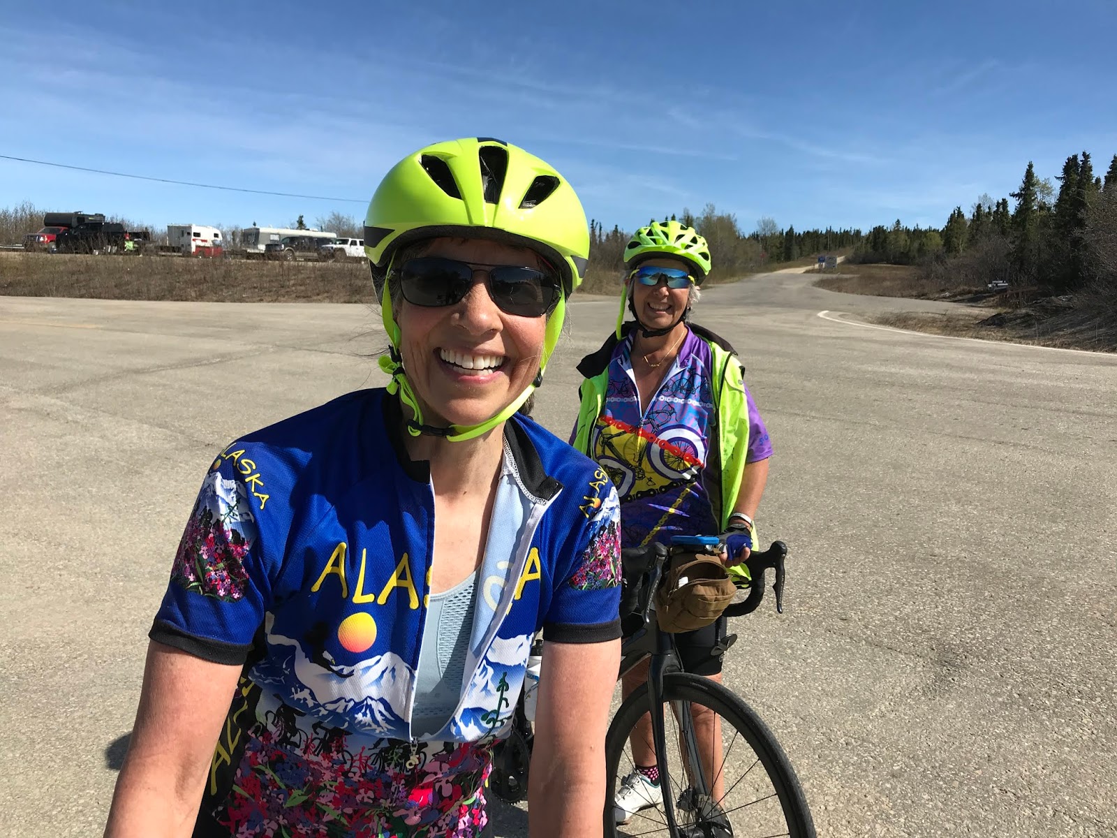
I had planned on biking to Manley Hot Springs this weekend, but the forecast called for 20-25 mph winds north of Fairbanks while the forecast for Denali was partly sunny with 10-15 mph winds. When has the weather ever been better in Denali than here in Fairbanks?  I made a last-minute decision and decided to head south and bike to Wonder Lake instead.  Eric was still recovering from a hip injury, so I went by myself.

I tried to find out if I needed a permit or if it was okay to camp in sight of the road but there were no clear answers.  I know of others who have camped before the bus service started and didn’t get backcountry permits.

I left town early and saw 3 fox even before I got to the park!  I was on the bike and climbing just after 9 AM.  It was fairly warm, plus I had a tail wind! People can still drive to Teklanika this week, so a few cars on the road but not too many since it was still early.  One car slowed down and the people stuck their heads out the window shouting and cheering.  It was none other than Lael Wilcox, Rue Kaladyte, and Christina Grande.  They were going to do a long day bike from Teklanika to Wonder Lake and back.  I figured I’d see them somewhere along the way.  At least I wouldn’t be the only one going past Polychrome.

This ride has a lot of climbing.  First 9 miles up the pavement.  Then the climb out of Savage River, followed by the climb out of Sanctuary.  Then the big climbs start.  Sable Pass, Polychrome Pass, Highway Pass, Stony, and finally Eielson.    6600 feet in 66 miles.  My legs were still tired from last weekend, but I had a tailwind and beautiful scenery to keep me going.

Gorgeous views all day!
Polychrome Pass

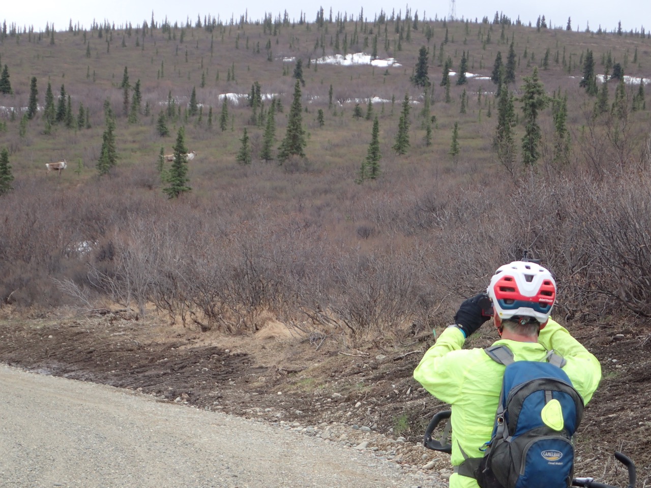
The mountain was out all day with just a few clouds moving in during the afternoon.  I saw a couple of moose plus lots of caribou, some crossing the road right in front of me.  Right before I got to Eielson, a ranger stopped to tell me that I couldn’t go past Eielson Visitor Center.  There was a rogue bear that had been causing havoc around Wonder Lake and Kantishna.  It had been breaking into buildings and had no fear of humans. She said I could camp around Eielson if I wanted.  I decided to eat dinner there and make a decision as to what to do.
Moose

Caribou
As I was finishing dinner, the trio of Lael, Rue and Christina showed up and we all took a break, reveling in the amazing views of Denali and planning races that should happen if somebody would just organize them! After they headed back, I found a spot to set up my tent.  Just as I was putting my food away a ranger showed up.  Oh, oh!  He asked if I had a backcountry permit and I answered honestly.  He then gave me a very nice, polite chewing out for not having one. He did say he wouldn’t make me bike all the way back out. And since the buses weren’t running, my tent was okay where it was at.  I apologized profusely.  He was nice about it and thankfully didn't write me up.  After he left, I had the place totally to myself.  The clouds cleared and Denali was out all night and the next morning.
Rue, Lael, and Christina at Eielson

Not a bad campsite for the night

I got up really early to head back before the winds picked up again (they had died down a bit overnight and I knew I would be riding into the wind on the way back).  The views of Denali kept me company all the way to Stony.
Breakfast view
How can you not smile when the sun is shining and Denali is out!

Another great day in the park

There was a bear on top of Stony but far enough away that I wasn’t too concerned.   I saw more caribou and lots and lots of snowshoe hares and ground squirrels.  As I started the climb up the back side of Sable Pass, I looked up and saw 2 bears very close to the road.  I stopped and waited, and waited, and waited.  I blew my whistle but they didn’t even look up.  I yelled and they just ignored me.  I ate lunch and peeled some layers.  They kept moving closer to the road and then started walking down the road towards me. I backed up and moved down the side road towards the E. Fork cabin.  Finally, an hour later they moved to the other side of the road, just far enough away I felt sort of comfortable passing them.  They barely looked up as I pedaled uphill as fast as I could. That adrenaline rush got me all the way back up to Sable Pass.
2 bears right next to the road!

Sheep off of Polychrome Pass

The rest of the ride was uneventful except for the stream of traffic coming out to Teklanika on a sunny Saturday.  With the headwind, the cars were all throwing up dust which was miserable to ride in.  I was never so happy to hit the pavement.  After one more climb, it was 9 miles downhill and back to my vehicle.
A train on the trestle bridge!

What a great couple of days!  I really timed it right for an overnight bikepack in Denali.  But next time I'll be sure and get a back country permit first!


Monday, May 25, 2020

My Everesting Attempt


Everest is a super high mountain. That fact really hit me when I was halfway done with my bike ride and still had over 14,000 more feet to climb.

I decided to try to “Everest” Cleary Summit on Saturday, May 23.  To “Everest” you bike up and down the same hill in one go until you have climbed 29,029 feet, the height of Everest.  A month ago I found out that endurance athlete Rebecca Rusch, known as the “Queen of Pain,” was doing a fundraiser, Giddy Up for Good, on Memorial Day weekend.  You bike any of 4 designated elevation distances to raise money for COVID relief and other agencies. The lowest elevation was 5,295 feet. The highest was Everest. I started thinking about attempting it but wasn’t sure.  If I signed up, I had to go for the biggest elevation.  I had already “Denali’d” on Ester Dome a few years ago with one of my 100 Miles of Nowhere challenges . (https://www.youtube.com/watch?v=f22lQVBQi-I). 
Denali is 20,000 feet. But 9000 more feet is a LOT more elevation.  

Several other Fairbanksans committed to the challenge.  Tyson Flaharty had his hat set on Everesting on Ester Dome.  Janice Onorato and Moreen Fried were going to go for the 5,295-foot Baked Potato (Rebecca Rusch is from Idaho) on the back side of Cleary Summit.  Tom Dale was also going for the Baked Potato but planned on riding with me later in the evening.

Could I do it? Did I want to? I would be trashed for a while.  I had time off the following week. Would I rather go on fun adventures or challenge myself along with hundreds of others to help raise money?  And if I was ever going to attempt an “Everest,” sooner is better than later.  I’m only getting older.  But I hadn’t been doing that much riding or hill-climbing. And the effort would take about 24 hours. Was it worth it?  Should I? Shouldn’t I?  A week before the event, with the weather forecast looking perfect, I decided, what the heck, and signed up.
Food prep the night before

I chose Cleary Summit. It has about 1100 feet of elevation over 3.5 miles with an average grade of 6%.  Not too steep, not too long and paved.  To climb 29,029 feet would take 27 laps. I decided to start on my road bike and switch to my mountain bike (which has lower gears) when my legs got tired. 

Saturday morning was sunny though a little chilly at 37 degrees.  But the forecast called for 70 degrees with calm winds, perfect for a long day on the bike. I parked at the Pedro Monument at 5:30 a.m. and started biking.

How to describe my ride? Up, down, up, down, up, down. Lots of traffic on the road, but only one that passed uncomfortably close. Most of the day I consistently took 31-33 minutes to go up and just 8 minutes to go down.  I stopped every 2-3 laps at my car to refuel, rest, use the restroom, and change layers. 
Stuffing my face with potato chips
Adding a hashmark for each lap to keep track

Resting and eating more
I had lots of company.  Thank you to everybody who came out!  The Swensons (Mike, David and Leslie), Alisabeth Thurston-Hicks, Frank Soos, Anna Rix, Barb Creighton, and Jane Lanford (running instead of biking!) all did laps with me. Mike and David came back later and did a second lap with me (you guys rock!).  Tom did his 5 laps. I told him to ride his own pace, so while we didn’t ride together, he cheered me on every time we passed. Fellow bikers Brenda Elmer, John Estle and Beth Zirbes all cheered me on while out for their Cleary Summit rides.  Eric came out and rode 2 laps with me as I was falling apart near the end. And on one lap, Moreen Fried and I summitted from opposite sides of Cleary Summit at the same time. What are the odds of that happening?!
Anna Rix joins me for a lap

Jane Lanford keeps pace on the steeper pitches.  I did get to the top before her!
Moreen and I summit from opposite directions at the same time!

I felt fine most of the day.  My legs held up okay.  A couple of times I thought I might start cramping, but I had some chicken broth and that helped.  I tried not to think about how many laps I had left – that was too overwhelming.  I just took it one or two laps at a time. My attitude stayed positive. I was eating and drinking according to plan.  I listened to music on a few laps and even sang out loud to some of my favorite tunes.
Another lap done.  Ready to head back down

But I started losing my appetite at about the halfway point (lap 13). Nothing sounded good to eat.  After finishing lap 15 with the Swensons and Barb, I swigged some Coke and sat down to rest.  I immediately felt nauseated. That’s when I threw up—several times.  How nice that my friends got to watch!  I took a Zofran (an anti-nausea medication) and had some broth. My friends had planned on going home after that lap, but were worried about leaving me. I explained that this is fairly normal for me on big efforts and convinced them I was fine to continue on my own.  
With Mike, Barb, and David starting up lap 15. Photo by Leslie

The next few laps were okay but not great. I continued to feel nauseated, especially on the downhills when I was resting.  I was able to drink chicken broth and get a GU down every other lap but that was it. Just contemplating anything else made me feel like vomiting. I switched to my mountain bike on lap 17 and my uphill times really tanked.  It took me over 40 minutes to climb, but at least I was able to keep going.  I kept hoping my stomach would recover – usually it does with fluids and sodium – but not this time.  
On the mountain bike for lower gears

Evening came and the temperatures started dropping.  I had a hard time staying warm on the downhills, even with extra layers.  After my 19th lap, I contemplated stopping.  I decided to ride one more lap.  

I was even slower – 47 minutes to the top. I was shivering when I got down again.  I took another Zofran and had some broth. I felt worse instead of better.  I still had 7,000 more feet to climb.  I couldn’t imagine doing it on no calories.  Plus it was just going to get colder overnight. 
Drinking broth to try and recover

I decided to stop.  Eric had been with me the last two laps, biking and taking photos. I had him record my “defeat” video, which was a bit hard. I cried a bit but not too much.  I did 22,144 feet elevation in 145.2 miles in just under 18 hours.  We packed up and went home, first stopping to cheer on Tyson, who had started his attempt on Ester Dome earlier that evening. He was on lap 11 when we saw him. (He later finished after nearly 18 hours.)


Cheering Tyson on as he starts back up Ester Dome.  This is after midnight.

As I’m writing this, two days later, I’m a little disappointed.  I wasn’t in danger. I was just uncomfortable. I guess I didn’t want it bad enough.  Not enough to suffer through the night, riding for another 6-7 hours on no calories and feeling nauseated the whole time.  Is that good or bad?  I’m not sure.  

I don’t like it when I don’t accomplish my goals.  Could I have finished if I had just kept on pushing? I’ll never know.  Does it matter? I like to think we are tougher than we think we are, but this time I wasn’t. Does it mean I’m getting soft?  Or does it mean that this goal just wasn’t that important to me?  I guess I won’t really know until the next challenge comes along.   

Will I continue to challenge myself as I get older?  I’m not sure. And that uncertainty bothers me.  Challenging ourselves (in any way – not just physically) helps us grow.  Will I be okay with myself if I become more complacent? Is it okay to stop challenging ourselves as we age?  Why am I worried about this anyway?  

Sigh. One of the downsides of not accomplishing a goal is the angst that goes along with it. But I guess it wouldn’t really have been a challenge if I knew I could complete it.  So, I’ll keep processing it and see what happens. 


Saturday, May 23, 2020

Satisfying Curiosity in the Donnelly Training Area


The views from atop Donnelly Dome are spectacular. But they are tantalizing, too. 

Corrine and I have been on top of the dome, just south of Delta Junction, several times. How can you not hike it? Its there every time you drive south on the Richardson Highway. Though dwarfed by the nearby Alaska Range, the dome dominates the Delta River plain out of which it rises. Its steep-but-not-dangerous flanks call to be hiked. It’s a fun, relatively short hike, and a popular destination for interior residents.


From atop the dome you can see a variety of trails, gravel roads, and lakes, all begging to be explored. For a variety or reasons, we had never been to most of them. For one, much of the land around the dome is in the Donnelly Training Area of Fort Greely. At first we didn’t know if civilians were allowed. If so, how do you get permission? We never bothered to find out. That area has lots of other adventures. (Check it out: www.salchadeltaswcd.org/trails/.) 


This spring, curiosity overcame inertia. I checked out the military recreation website (https://usartrak.isportsman.net/) and learned that getting a permit was relatively easy. We decided to make a full day of climbing the dome and exploring the gravel roads west of the Richardson Highway by bike. Getting a good road map for the area was a bit tricky, but I printed out several maps I found online (and then forgot them at home). Fortunately, I also downloaded a GPS-enabled PDF map from the website to my phone. (The fishing map has a good road map. Google Maps works well but doesn’t include off-limits areas.)


We left Fairbanks at about 8 a.m. on a Saturday in mid-May and arrived at the dome a couple hours later. We decided to hike the southern approach, since the northern side still had snow and probably mud. 


We were happy to get climbing and warm up, since temperatures were in the low 40s. The climb is a thigh-burner, but you get great views quickly. Every time I’ve climbed the southern side I’ve looked down on a 4WD trail that heads east from the Richardson Highway past Jarvis Creek and on toward Granite Mountain. And every time I’ve said I should bike that trail at least to Jarvis Creek. I pitched the idea to Corrine and she was game. 


“This trip is about exploring,” she said. 


A pasque flower on the flanks of Donnelly Dome. 

In less than an hour, we crested the gentle upper slope that leads to the top of the dome and were greeted with a chilly breeze. Fortunately, the forecast called for warmer temperatures later. At the summit we put on more layers and looked down on the roads we planned to bike, eager to explore. 


Requisite selfie from atop the dome!

We also had to chase away a bold ground squirrel that had almost no fear of humans. It came out of a human-built rock wall and nibbled on Corrine’s pack after she put it down. Later, the little bugger started checking out Corrine’s shoes, when she was still in them! 


This ground squirrel certainly didn't fear humans!

After a short break, we headed back down. By then the chilly breeze wrapped around that side of the dome. Brrr. The forecast had called for temps in the high 50s and we were looking forward to that. 

Donnelly Dome hike map
(At the base of the dome, we took a different route back to the car
to see what it was like: brushier and longer, but doable)


Back at the car, already two other cars were in the small pullout. We drove about a half-mile north on the Rich, parked at the beginning of the 4WD trail that headed toward Jarvis Creek, and started biking. Finally, I’d get to see where this trail went! 

We quickly ran into a small creek crossing that was bikeable but left us with wet feet. (A minor casualty of exploring.) The trail has a few forks. One ended at Ober Creek, a tributary of Jarvis. The main trail toward Jarvis Creek crossed a wet, muddy area, so we left that for a drier day later in the summer. 


We tried to find a way around to keep our feet dry, but no luck.

We headed north on yet another trail, which paralleled the Richardson Highway. It took us out into a flat plain dominated by Donnelly Dome. Eventually we hit a road that headed out to the Rich. Just off the highway a signboard has recreation information from the military. The map showed a whole maze of trails and roads off to the east. Another day. We wanted to check out those gravel roads west of the highway.


After about a quarter-mile north on the Rich, we turned west onto Dome Road, which also has a recreation signboard. While the east side of the highway is flat, the west side is hilly. Dome Road, a gravel road, quickly starts climbing and heads toward the northern side of Donnelly Dome.


Corrine bikes Dome Road toward Donnelly Dome. 

We followed it past the parking area for the dome’s northern approach and under the Trans-Alaska Pipeline to where Dome Road ends at Old Rich, another gravel road. After consulting the map on my phone, we headed north and down, down, down toward an area with several small lakes, planning to eat a late lunch at one. We stopped on the descent to put on more layers. Where were those warmer temps?! On the way down a group of four caribou, all dressed in coats of tan and white, crossed the road in front of us. 


Eric bikes under the Trans-Alaska Pipeline

We turned on to Windy Ridge Road and soon hit the area with lakes, which are stocked with fish. We rode to Nickel Lake, where we put on more layers and had a peaceful, though chilly, lakeside lunch. We talked about how that area would have been nice to visit when our kids were young. Lakes for fishing and canoeing, trails to explore, low-traffic roads for biking. 


Corrine bundled up for lunch.

After lunch we rode further on Windy Ridge to where it overlooks the flats bordering the Delta River. We could see more lakes, but it was almost 4 p.m. With more time we could have done a nice gravel road loop: Windy Ridge to Meadow Lakes Road to the Old Rich, connecting the last two with less than a mile of the Richardson Highway.


Tempting to ride farther, but we were running out of time.

We headed back up, up, up, happy for the climbing to help keep us warm. (Still no warmer temps!) We passed Dome Road and followed the Old Rich past two more stocked lakes. On the way, we saw more caribou and Corrine saw a moose with a calf. The area has quite a bit of wildlife. I had seen another cow and calf earlier on the east side of the highway. Bison are sometimes in the area, but unfortunately we didn’t see any. 


Eric takes photos of some caribou.

I was curious about where the Old Rich ends. At mile 243 of the Richardson Highway, south of the dome, an old 4WD trail leaves the highway. It’s obvious when driving north and I’ve often been curious about where it went. But that rough trail was not anything like the wide, smooth gravel road we were on.

The Old Rich finally ended in a cul-de-sac, where a rough but bike-able 4WD trail continued south.  The trail, which has extensive erosion, descends about a mile and comes out at Mile 243. Mystery solved! From there it was about four miles on the Richardson back to our car for a round-the-dome trip of about 30 miles.


Corrine bikes out of the trail to Mile 243 of the Richardson Highway.
Donnelly Dome bike circumnavigation map

Driving through Delta Junction we stopped at the Buffalo Center Drive-In and had halibut and fries. Mmmmm! (Cash only, but luckily we had enough.) The drive-in is take-out only due to the pandemic, but we found a nearby picnic table. A chilly wind encouraged us to eat quickly. (We never did get those warm temps!) We drove back to Fairbanks with full bellies and content to have solved some of the mysteries around Donnelly Dome.


If You Go

Donnelly Training Area
This area has recreational opportunities for hikers, bikers, fisherman, OHVers and lots more, but to use the area you need a Recreational Access Permit (RAP). The permit is free and easy to get. Go to the US Army Garrison Alaska iSportsman website (https://usartrak.isportsman.net/) and follow the instructions. The training area is sometimes closed, so make sure to read the website carefully and learn how to check in before you go. Then check out the rest of the website, which has maps and recreation information for the Donnelly Training area and other military lands in the interior that are open to civilian recreational use. 

Donnelly Dome
Most of the dome, including the summit, is in the Donnelly Training Area of Fort Greely so you need a RAP (above). 
The dome has two approaches. Neither has an official trail, but both have informal trails. The northern one has less elevation gain and is less steep, but snow lingers later in the year and parts of it can be muddy. The trail is a bit hard to find from the bottom, though it is sometimes marked. You should find it with a bit of poking around. 
The southern approach is drier but steeper. The trail braids many times, but keep to the main trail to the left on the way up you should be fine. If you plan to return the same way, pay attention to landmarks. It’s easy to get off trail. However, it’s easy to see the lower part of the trail and get back on the right path. The parking lot spot and lower flanks of the southern side of the dome are just outside of military land. 
Both approaches and getting to the respective parking areas is described in this guide: www.salchadeltaswcd.org/donnelly-dome/. For information on other trails in that area see the rest of that website from the Salcha-Delta Soil and Water Conservation District (www.salchadeltaswcd.org/trails/). 


Tuesday, May 12, 2020

Mount Margaret on Mother's Day

Corrine takes a photo of Denali while Eric takes a photo of Corrine.
Sometimes it’s good to try something on a whim. You might end up cold and with wet feet but a smile on your face.

For Mother's Day Corrine had suggested hiking the Savage Alpine Trail in Denali National Park. We had heard it was in pretty good shape, and neither of us had done that one in a while. It was a good plan.

We got an early start to beat the crowds we had heard had been collecting at Denali after the road recently opened. We arrived around 9 a.m., and already several cars were on the road. But when we neared the easternmost trailhead of the Savage Alpine Trail we were greeted with a sign: "Trail Closed Due to Dangerous Wildlife Activity." We had heard about a grizzly in the area a few days earlier, so we should have figured that might be a possibility.

We decided to check the trailhead at the Savage River parking lot, but that whole lot was closed. We kept driving and discussing, finally deciding to park at the Teklanika rest stop and walk along the river.

A couple of miles past Savage River, the road tops out and winds around the nose of a ridge. As we drove by I mentioned how I've often wanted to hike that ridge toward Mount Margaret. It's above treeline and is a mostly gentle climb to the top. Corrine pointed to a large pullout and said "We could park there." After a moment I realized she was suggesting we give it a try. I hesitated. The ridge had a lot of snow patches. But driving all the way to Teklanika trying to pass a lot of really poky drivers didn't appeal to me. Doing something new did. We parked.

Within 10 minutes we had wet feet! While trying to cross a small meltwater stream, I stepped on what appeared to be a solid bump of tundra and got a wet foot when it sunk like a sponge. Corrine decided to cross the snow patch above the stream. That worked. Until it didn't. She sunk into the snow and the stream hidden below! We forged on, still trying to keep to dry ground despite our wet feet. We still had to cross several snow patches until we finally attained the steeper slope, which had less snow.

Corrine gets her feet wet!
Corrine hikes on the steeper part of the ridge with Denali just visible in the background.
Signs of life were here and there. We saw several birds but no other wildlife.
As we climbed, the breeze picked up. We finally crested one hill and got a view of a vast plateau atop Mount Margaret. The higher part of the mountain to the east was blocked by large snowfields. We headed west, picking our way through snow patches and across wet ground, aiming for a rock outcropping. A strong wind blew at our backs, so we sought shelter behind the outcropping. No luck! The wind swirled around everything. Places that might offer shelter were still covered in a lot of snow. We were both getting a bit cold and put on extra top layers.

Little color this early, but there was a bit if you looked for it.
The plateau had snow patches and a lot of wet ground, but you could pick your way around it.
"Let's head back and we can eat at the car," Corrine said. I agreed.

We climbed over the rock outcropping and suddenly we could see a sheep trail, free of snow, heading along the ridge toward the higher part of Mount Margaret. We had walked right over it, oblivious!

"Look at that," I said, pointing.

"Let's do it," Corrine said.

The heck with the cold. Destiny called!

We headed up the dry, snow-free trail, climbing higher on the mountain. We could see the valleys to the north and south of the mountain. Denali rose off to the southwest, the top obscured by clouds.

Corrine hiking on the sheep trail.
We stopped before what appeared to be the last pitch to the top. It looked doable, but steep and rocky. I found a mostly sheltered spot behind the ridge, where we had just room enough to sit and eat our lunches. Still a bit windy there, but much better than atop the ridge.

A winderful lunch spot! The last pitch is in the background.
We discussed what to do next.

"I'm ready to head back," Corrine said.

I was a little surprised, as Corrine usually has hotter summit fever than I do, but I agreed. I had forgotten my gloves back at the car, and my hands were cold. I was fine with going back. As soon as we got back to the ridge Corrine looked up at the last pitch.

"We should do it, or at least give it a try," she yelled over the wind.

I immediately agreed. It doesn’t take much to spark my summit fever.

We threaded our way up the steep face and were soon on top of Mount Margaret, wind blowing hard. Corrine and I had climbed part of this mountain several years earlier, using a steep approach from the northern end of the Savage River Loop Trail. On that trip the wind howled so strong we had a hard time walking, so we headed down quickly without summiting. This time we stayed long enough on top for a couple of selfies.

Corrine on the last pitch before the summit.
Corrine on top. (She hates how her headband looks in this photo, but the selfies are still on her phone!)
Now we had a choice: head back the way we came or attempt to cross the large snowfield below us and see if we could descend the ridge to the east of the one we had ascended. We both love loops, but we weren't sure how the firm the snow would be.

"Look, there are some people down there crossing the snow," Corrine said, pointing. "They aren't having any problems."

I never did see these so-called people, but that decided it for us. We headed down and stepped out onto the snowfield. And it worked. Until it didn't.

We would walk along on top of the snow for a few steps, then one leg would suddenly sink knee- or thigh-deep. Maybe a couple more postholes, then more surface walking, then another plunge step into the saturated snow. Our shoes were soon soaked with freezing cold water. But it was funny, too. I smiled as I watched Corrine daintily walk across the top of the snow, suddenly break through, and then wallow around until she was walking on the surface again. I’m sure I looked just as silly.

Corrine wallowing in the snowfield.
We finally got to dry ground and wrung out our socks. Down lower it was less windy and warmer, so we each peeled a layer.

Feet are happier when the socks are drier!
We followed a sheep trail down the ridge and soon ran into a group of people hiking up the lower part of the trail, which looks like it has become a human social trail. (Back home I found that route was mentioned by Ike Waits in his book “Denali National Park: Guide to Hiking, Photography and Camping.”)

We lost the trail amid snow patches and thick alders, but the park road was visible in front of us. We thrashed our way down, finding bits and pieces of game trails, until we got to the road. From there it was a little over a half-mile to our car.

We sealed the hike with a kiss and decided that despite the wind and cold feet, the outing had been much better than what we had planned.