
The views from atop Donnelly Dome are spectacular. But they are tantalizing, too.
Corrine and I have been on top of the dome, just south of Delta Junction, several times. How can you not hike it? Its there every time you drive south on the Richardson Highway. Though dwarfed by the nearby Alaska Range, the dome dominates the Delta River plain out of which it rises. Its steep-but-not-dangerous flanks call to be hiked. It’s a fun, relatively short hike, and a popular destination for interior residents.
From atop the dome you can see a variety of trails, gravel roads, and lakes, all begging to be explored. For a variety or reasons, we had never been to most of them. For one, much of the land around the dome is in the Donnelly Training Area of Fort Greely. At first we didn’t know if civilians were allowed. If so, how do you get permission? We never bothered to find out. That area has lots of other adventures. (Check it out: www.salchadeltaswcd.org/trails/.)
This spring, curiosity overcame inertia. I checked out the military recreation website (https://usartrak.isportsman.net/) and learned that getting a permit was relatively easy. We decided to make a full day of climbing the dome and exploring the gravel roads west of the Richardson Highway by bike. Getting a good road map for the area was a bit tricky, but I printed out several maps I found online (and then forgot them at home). Fortunately, I also downloaded a GPS-enabled PDF map from the website to my phone. (The fishing map has a good road map. Google Maps works well but doesn’t include off-limits areas.)
We left Fairbanks at about 8 a.m. on a Saturday in mid-May and arrived at the dome a couple hours later. We decided to hike the southern approach, since the northern side still had snow and probably mud.
We were happy to get climbing and warm up, since temperatures were in the low 40s. The climb is a thigh-burner, but you get great views quickly. Every time I’ve climbed the southern side I’ve looked down on a 4WD trail that heads east from the Richardson Highway past Jarvis Creek and on toward Granite Mountain. And every time I’ve said I should bike that trail at least to Jarvis Creek. I pitched the idea to Corrine and she was game.
“This trip is about exploring,” she said.
 |
| A pasque flower on the flanks of Donnelly Dome. |
In less than an hour, we crested the gentle upper slope that leads to the top of the dome and were greeted with a chilly breeze. Fortunately, the forecast called for warmer temperatures later. At the summit we put on more layers and looked down on the roads we planned to bike, eager to explore.
 |
| Requisite selfie from atop the dome! |
We also had to chase away a bold ground squirrel that had almost no fear of humans. It came out of a human-built rock wall and nibbled on Corrine’s pack after she put it down. Later, the little bugger started checking out Corrine’s shoes, when she was still in them!
 |
| This ground squirrel certainly didn't fear humans! |
After a short break, we headed back down. By then the chilly breeze wrapped around that side of the dome. Brrr. The forecast had called for temps in the high 50s and we were looking forward to that.
 |
| Donnelly Dome hike map (At the base of the dome, we took a different route back to the car to see what it was like: brushier and longer, but doable) |
Back at the car, already two other cars were in the small pullout. We drove about a half-mile north on the Rich, parked at the beginning of the 4WD trail that headed toward Jarvis Creek, and started biking. Finally, I’d get to see where this trail went!
We quickly ran into a small creek crossing that was bikeable but left us with wet feet. (A minor casualty of exploring.) The trail has a few forks. One ended at Ober Creek, a tributary of Jarvis. The main trail toward Jarvis Creek crossed a wet, muddy area, so we left that for a drier day later in the summer.
 |
| We tried to find a way around to keep our feet dry, but no luck. |
We headed north on yet another trail, which paralleled the Richardson Highway. It took us out into a flat plain dominated by Donnelly Dome. Eventually we hit a road that headed out to the Rich. Just off the highway a signboard has recreation information from the military. The map showed a whole maze of trails and roads off to the east. Another day. We wanted to check out those gravel roads west of the highway.
After about a quarter-mile north on the Rich, we turned west onto Dome Road, which also has a recreation signboard. While the east side of the highway is flat, the west side is hilly. Dome Road, a gravel road, quickly starts climbing and heads toward the northern side of Donnelly Dome.
 |
| Corrine bikes Dome Road toward Donnelly Dome. |
We followed it past the parking area for the dome’s northern approach and under the Trans-Alaska Pipeline to where Dome Road ends at Old Rich, another gravel road. After consulting the map on my phone, we headed north and down, down, down toward an area with several small lakes, planning to eat a late lunch at one. We stopped on the descent to put on more layers. Where were those warmer temps?! On the way down a group of four caribou, all dressed in coats of tan and white, crossed the road in front of us.
 |
| Eric bikes under the Trans-Alaska Pipeline |
We turned on to Windy Ridge Road and soon hit the area with lakes, which are stocked with fish. We rode to Nickel Lake, where we put on more layers and had a peaceful, though chilly, lakeside lunch. We talked about how that area would have been nice to visit when our kids were young. Lakes for fishing and canoeing, trails to explore, low-traffic roads for biking.
 |
| Corrine bundled up for lunch. |
After lunch we rode further on Windy Ridge to where it overlooks the flats bordering the Delta River. We could see more lakes, but it was almost 4 p.m. With more time we could have done a nice gravel road loop: Windy Ridge to Meadow Lakes Road to the Old Rich, connecting the last two with less than a mile of the Richardson Highway.
 |
| Tempting to ride farther, but we were running out of time. |
We headed back up, up, up, happy for the climbing to help keep us warm. (Still no warmer temps!) We passed Dome Road and followed the Old Rich past two more stocked lakes. On the way, we saw more caribou and Corrine saw a moose with a calf. The area has quite a bit of wildlife. I had seen another cow and calf earlier on the east side of the highway. Bison are sometimes in the area, but unfortunately we didn’t see any.
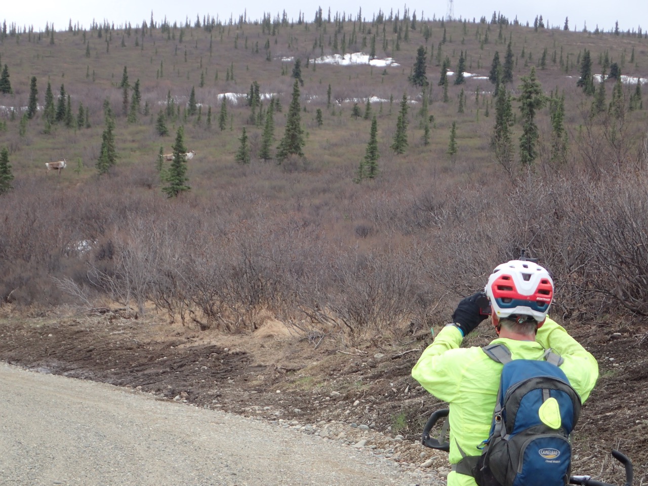 |
| Eric takes photos of some caribou. |
I was curious about where the Old Rich ends. At mile 243 of the Richardson Highway, south of the dome, an old 4WD trail leaves the highway. It’s obvious when driving north and I’ve often been curious about where it went. But that rough trail was not anything like the wide, smooth gravel road we were on.
The Old Rich finally ended in a cul-de-sac, where a rough but bike-able 4WD trail continued south. The trail, which has extensive erosion, descends about a mile and comes out at Mile 243. Mystery solved! From there it was about four miles on the Richardson back to our car for a round-the-dome trip of about 30 miles.
 |
| Corrine bikes out of the trail to Mile 243 of the Richardson Highway. |
 |
| Donnelly Dome bike circumnavigation map |
Driving through Delta Junction we stopped at the Buffalo Center Drive-In and had halibut and fries. Mmmmm! (Cash only, but luckily we had enough.) The drive-in is take-out only due to the pandemic, but we found a nearby picnic table. A chilly wind encouraged us to eat quickly. (We never did get those warm temps!) We drove back to Fairbanks with full bellies and content to have solved some of the mysteries around Donnelly Dome.
If You Go
Donnelly Training Area
This area has recreational opportunities for hikers, bikers, fisherman, OHVers and lots more, but to use the area you need a Recreational Access Permit (RAP). The permit is free and easy to get. Go to the US Army Garrison Alaska iSportsman website (https://usartrak.isportsman.net/) and follow the instructions. The training area is sometimes closed, so make sure to read the website carefully and learn how to check in before you go. Then check out the rest of the website, which has maps and recreation information for the Donnelly Training area and other military lands in the interior that are open to civilian recreational use.
Donnelly Dome
Most of the dome, including the summit, is in the Donnelly Training Area of Fort Greely so you need a RAP (above).
The dome has two approaches. Neither has an official trail, but both have informal trails. The northern one has less elevation gain and is less steep, but snow lingers later in the year and parts of it can be muddy. The trail is a bit hard to find from the bottom, though it is sometimes marked. You should find it with a bit of poking around.
The southern approach is drier but steeper. The trail braids many times, but keep to the main trail to the left on the way up you should be fine. If you plan to return the same way, pay attention to landmarks. It’s easy to get off trail. However, it’s easy to see the lower part of the trail and get back on the right path. The parking lot spot and lower flanks of the southern side of the dome are just outside of military land.
Both approaches and getting to the respective parking areas is described in this guide: www.salchadeltaswcd.org/donnelly-dome/. For information on other trails in that area see the rest of that website from the Salcha-Delta Soil and Water Conservation District (www.salchadeltaswcd.org/trails/).
No comments:
Post a Comment