Thursday, October 8, 2020

Top 10 Best Roads to Bike in Interior Alaska


Plans went awry this summer. I was going to challenge myself with 2 big bike races, the Dirty Kanza Extra Large and the Trans South Dakota. Due to COVID and travel restrictions, I was unable to do either.  So instead, I biked local roads.  I ended up biking all of the roads that leave from Fairbanks – a sum total of 5!  I also rode most of the classic gravel rides that are close to home.  I used my hardtail mountain bike on most of them since I don't have a gravel bike and because they were often part of a bigger adventure that I was on.  In the style of David Letterman, I am doing my top 10 biking roads that I did in the Interior.

10.  Richardson Highway – August 1 – 139 miles with 5526 feet elevation gain

I biked from Donnelly Creek Campground back home.  Although the highway south of Delta Junction is beautiful, the portion from Delta Junction to Fairbanks is less scenic and fairly flat and that’s the majority of what I rode this summer.  The closer you get to Fairbanks, the busier the road gets with constant noise and traffic. If you want to bike this road, start in Delta Junction and bike south towards Valdez.  That part is amazing!  

High points – Views of the Alaska Range and ice cream at the Knotty Shop. 

Low points – Too much traffic.


9.  Chena Hot Springs Road – August 29 - 101 miles with 3224 feet elevation gain

This road is 56.5 miles long and ends at Chena Hot Springs. It has good pavement but half of it has no shoulder.  The first half has rolling hills, but the second half is basically flat so you can really cruise!  I think the second half is more scenic.  My plan had been to bike from home to the hot springs and back, but I wasn’t feeling it that day, so Eric picked me up on my way back to make it a century ride. I left early, so didn’t have too much traffic until later in the day. Best time to do it is as part of the annual Chena Hot Springs Ride (which was unfortunately canceled due to COVID this year).

High Points – Biking along at over 20 mph on the flats. Chance to soak in Chena Hot Springs at the end.

Low Point – Too much traffic and no shoulder.


8. Parks Highway – July 22 - 128 miles with 6439 feet elevation gain

This road is also 100% paved and quite scenic.  I’ve done it the past 4 years with friends as a century ride to 49th State Brewing company.  Heading south from Fairbanks, the first half is very hilly.  The second half is much flatter although it trends uphill and there are usually headwinds. Nenana is about halfway, so a good place to stop and rest and refuel. This time I was totally loaded for bikepacking on my mountain bike so was much slower. It was cool and rainy the day I did it. I rode from home to the Riley Creek Campground in Denali National Park.

High Point – Minimal headwind for the first time ever!

Low Point – 2 flats in less than 24 hours - this did convince me to finally go tubeless on my mountain bike.


7.  Steese Highway – June 27 - 155 miles with 9390  feet elevation gain 

I’ve biked out to the Chatanika Lodge and back endless times, but I had never done the entire road all the way to Circle.  The ride up to Eagle Summit is great! Central to Circle is not worth it unless you really want to see the Yukon River.  I had great weather for this ride. Paved to about mile 60 then gravel which was good until after Central.

High Point – Amazing scenery from 12 Mile Summit to Eagle Summit

Low Point – The road conditions from Central to Circle really deteriorated and there was so much traffic with fast cars throwing up dust.  Found out later, there were 2 funerals going on in Circle that weekend.


6.  Nabesna Road – July 25 - 40.3 miles with 1955 feet elevation gain

This road starts at mile 60 of the Tok Cut Off and is 42 miles long. The first few miles are paved. We had a cabin at mile 20 so Eric and I only rode from there to the end of the road and back.  Great biking.  Fairly flat. Minimal traffic.  Several stream crossings that sometimes can be impassable during times of high water.  

High Points – Great scenery and had fun on the stream crossings although we got wet feet! And we ran into friends also out biking the road!

Low Points – Didn’t get to bike the entire road.


5. Murphy Dome Road down to Chatanika River and back – June 20 – 80 miles with 8483 feet elevation gain

If you want a lot of climbing on gravel, this is the ride for you.  I started at my home, climbed all the way up Murphy Dome by way of Lincoln Creek Subdivision, then down the 14-mile trail to the Chatanika River.  Then it’s a long climb back up but a fast descent back down Murphy Dome Rd.  The road down to the Chatanika River is the best part.  You have views down into the Minto Flats and the riding is not too steep or technical.

High Points – Great views up high on Murphy Dome Rd. Love climbing on good gravel.

Low Points – I got caught in a pretty good rainstorm on the way back.


4.  Elliot Highway - June 6 - 155 miles with 11,490 feet elevation gain 

I've road biked to Wickersham Dome many times but had never been to Manley at the end of the road.  Well worth going. The first half is paved but turns to gravel after you pass the Dalton Highway turn off. Most of the ride is very hilly but incredibly scenic. Once you pass the Dalton Highway there is almost no traffic.  I think I saw about one car/hour!

High Points – Great riding on ridges with great views and almost no traffic

Low Points – Manley store has limited hours and was closed when I got there.  I think the Hot Springs is available if you call, but I didn’t have time to do this.  


3. Denali Highway – Aug 22 – 100.7 miles with 6535 elevation gain followed by 100 miles with 4682 feet elevation the next day.
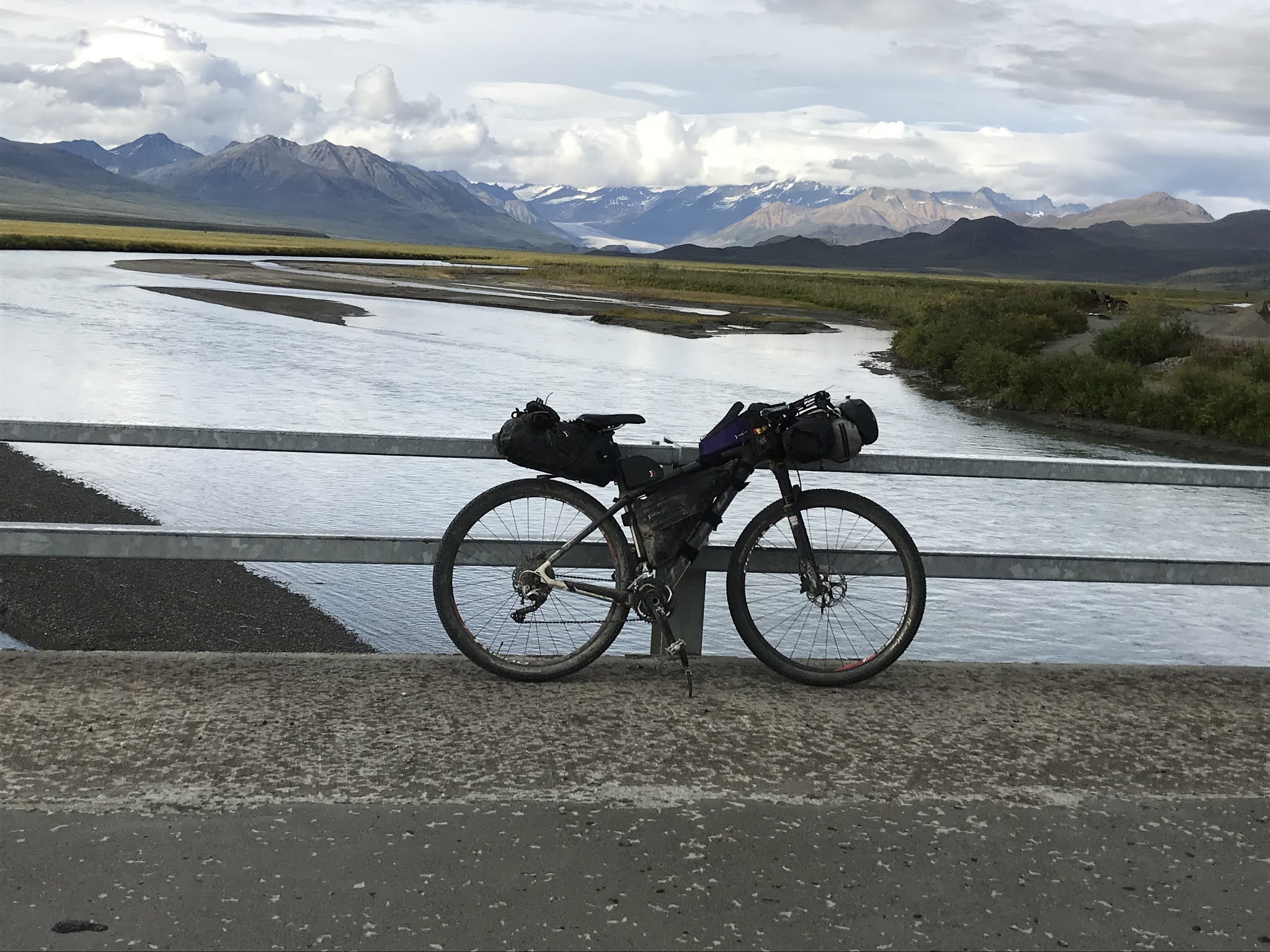
I love the Denali Highway.  It is a 135-mile mixed surface road ( some gravel, some chip seal and more pavement every year) that runs from Cantwell to Paxson. Big expansive vistas with mountains, glaciers and rivers. I was there during hunting season so lots more traffic than usual.  I was a week early for prime fall colors.  This is a must-do ride. 

High Points – amazing scenery

Low Points – would recommend not going during hunting season

2. Petersville Road – Sept 10 – 50 miles with 3684 feet elevation gain

Okay, technically this road is not in the Interior but close enough.  It starts just north of Talkeetna off the Parks Highway.  It is about 35 miles one way to Cache Creek with the first 10 miles paved.  This road is very fun to bike.  Lots of little ups and downs and swoopy curves.  Lots of potholes but easily avoidable on a bike.  More fun to bike than to drive. There are many ATV trails to explore that take off from the road, too. On a clear day, there are amazing views of Denali and the Alaska Range.  We drove to Gate Creek Cabins at mile 10, where we spent 3 nights.  If you have time, hike up into Peters Hills for even more amazing views of Denali. Maybe it was the perfect weather or the colors but I really loved biking this road.

High Points – Great gravel riding, amazing views and spectacular fall colors.

Low Points – We had such a perfect weekend that I can’t think of any low points except it was a little chilly early in the morning.


1. DENALI PARK ROAD - May 29 – 66 miles with 6663 elevation gain followed by 66 miles with 4537 elevation gain the next day.

Love, love, love the Denali Park Road.  It’s an amazing place to ride your bike.  I go down and ride every year.  This year I rode to Eielson Visitor Center and back over 2 days.  Early in the season you can drive to Teklanika and do an out and back from there.  You can also catch a bus in and then bike out. Or get a permit or campsite and bike in and camp and then bike out the next day. The entire road out to Wonder Lake is 85 miles one way.  I always see wildlife and often I’ve timed it right to see Denali.  This year I had the best of everything.

High Points – Wildlife and views of Denali

Low Points – Dusty from buses and cars passing. Bus drivers are extremely courteous and slow down. It can be windy and rainy, although I lucked out with weather this year.  

Really Any Road in Interior Alaska is the best

Old Murphy Dome Road, Goldstream, Farmer’s Loop and all the other paved roads, gravel roads and ATV trails that abound in interior Alaska. Overall, we have amazing roads with minimal traffic and awesome scenery.  I’ve biked close to 5000 miles this year, all on local roads and trails. And I’ve enjoyed almost every mile of it.  So get out there and ride your bike!


Sunday, September 13, 2020

Perfect Timing on the Petersville Road


Oh. My. Gosh.  Can you believe this? Absolutely amazing!  

These and other superlatives kept coming this weekend as we biked and hiked along the Petersville Road

Neither Eric nor I in all of our years in Alaska had ever been down this road, though we had considered it many times.  Well, it’s definitely not to be missed, especially if you have a few days like we did.  Sunny skies, minimal winds, no bugs, and fall colors at their prime.  It was jaw-dropping spectacular.  (Another superlative!)

I had a few days off from work as I was supposed to be racing the Dirty Kanza Extra Large, a gravel bike race that was rescheduled from May and rescheduled again until next year due to Covid. The weather forecast for Fairbanks was grim with rain likely most days.  But it looked like it might be nice south of the range.  I was having a hard time motivating due to the weather, but then I remembered that Lael Wilcox had just ridden the Petersville Road.  It looked interesting and was somewhere new to explore. After an internet search I found the Gate Creek Cabins, which are just at the end of the paved part of the road, 10 miles in. The cabins are fully furnished, with electricity and running water.  I called and they had availability.  I must be getting soft in my old age, but it was just the nudge I needed to motivate to get out of town.  Whatever it takes.  As always, Eric was right on board and ready to see some new country. (The cabins were wonderfully run. A great place to stay!)

It rained the whole way down from Fairbanks, so we were really happy we had a dry, warm cabin waiting.  By the time we went to bed, the skies had started clearing. 

PETERSVILLE ROAD BY BIKE

The next morning was cool and sunny. We were ready for some adventuring! I wanted to bike to the Cache Creek crossing (about 35 miles from the Parks highway) but also wanted to explore some of the side ATV trails if possible.  Eric wasn’t sure how much biking he wanted to do, so we drove to just past the Forks Roadhouse (now closed), at about 20 miles in, and started from there.  On the drive, the views started immediately with Denali and the surrounding peaks all out in their glory. Several open areas across swampy meadows offered outstanding views.  We also noted that almost every pullout had at least one truck, ATV or RV. Some had several. Hunting season was definitely on.  Even so, the traffic was minimal. We guessed that most hunters were out on the many trails that took off from the road. 

Dawn sunlight on Denali and surrounding mountains


RV's and trucks at every pullout

The road was a lot of fun to bike. Fairly short uphills with nice grades.  Fun, swoopy downhills going in and out of drainages.  Mostly good gravel with lots of potholes, though easily avoided on bike.  The scenery kept changing between woods and meadows, with the big mountains and nearby hills providing a backdrop.  It was such a glorious day that we kept stopping to take photos.  The fall colors were absolutely stunning.  Our cameras just couldn’t capture the glowing yellows and reds, but we kept trying.


Just before the “community” of Petersville, we followed a side road for a bit until it ended at what appeared to be a private mine with a family and their RVs.  Back on the main road we passed through Petersville, a collection of about four or five buildings, obviously lived in and well taken care of. We followed the road through a very scenic canyon and then bombed down the other side, crossing Peters Creek on a bridge.  As the day wore on, the big mountains became shrouded in clouds, but the fall colors and hillsides were still amazing.  We kept stopping to take photos and look around. 

Getting close to the metropolis of Petersville

Looking down on Petersville

North side of the canyon

After the bridge we saw a side road to the right going way back up into the Dutch Hills just north of the Peters Hills.  (These “hills” would be mountains in other places, but when you’re right next to Denali you become a hill.) We could see some buildings and vehicles way up there. It looked intriguing so we followed it. We had to ride through some puddles but then came to another crossing of Peters Creek, this time without a bridge.  We easily crossed the first braid, but the main channel was over knee deep. We weren’t sure we wanted to get that wet.  The air temperature was only around 45F.  Plus, a few minutes before, a guy on an ATV warned Eric that he had seen a wounded black bear a couple of miles up the road. That all was enough to get us to give up on that route, especially since we still hadn’t been to the end of the main road. We wistfully looked at the continuing side road then let common sense prevail and turned back.

Eric crosses the easy braid of Peters Creek

The main road climbed out of the Peters Creek drainage and became rougher, though still passable by 2-wheel drive.  After about 20 miles of biking we came to the Cache Creek crossing, which had no bridge. We could have waded it, but we had read that private property not far on the other side would block our path.  Plus, we had to bike back nearly 20 miles and we still hadn’t eaten our lunch.  So, we turned around, leaving that exploring for another day.


Contemplating whether to go on or turn around

We biked up a steep narrow side road and were surprised to find a large RV at the top. Miners get those things in some incredible places. We started on a side trail from that road, but after having to cross some tricky puddles, we stopped for lunch. We decided that side trail was more “exploring for another day.”

Not a bad lunch spot

Heading back down to the main road

The bike back on the main road was just as much fun as on the way in. We had to climb to get through the canyon, but then it was rolling hills, mostly trending downhill.  When we got back to the car, I decided to bike the last 10 miles back to our cabin while Eric drove the car. 


PETERS HILLS HIKE

The next morning, we got up early to hike into Peters Hills.  We wanted to be up high to see the mountains before the afternoon clouds covered them up.  (Little did we know that the mountains would be out all day!)  We drove back to about a mile past Petersville and started hiking on a steep ATV trail.  (Read about this hike in “55 Ways to the Wilderness in Southcentral Alaska.”) 

The first part of the trail was rutted and muddy

The morning was cool and crisp, right around freezing, but we warmed up as we headed uphill.  We followed some bear tracks on an often-muddy ATV trail and after a couple of miles broke out into tundra.

Bear tracks!

Tundra hiking

At about mile 3 we hit a high point (2840’) and the view opened up.  OMG! It was absolutely jaw-dropping, amazingly spectacular.  Denali, Mt. Hunter, Mt. Foraker, and all the surrounding peaks were in view with the morning sunlight on them. The sky was crystal clear blue.  Small lakes dotted the nearby tundra, aglow in reds.  We just couldn’t believe our luck.  We must have picked the best day of the year to be up there.  

We continued hiking off-trail across a valley and then up a steep climb to a higher overlook (3600’). The views just kept getting better. Here, about 7 miles in, signs told us we had crossed into Denali State Park. But we weren’t done. An even higher point, farther east, beckoned. 


We headed down and passed what has to be one of the world’s most glorious camping spot – a flat soft surface on a mountain lake with a full view of Denali.  We mourned leaving our tent and sleeping bags behind! 

Primo backcountry camp site.  Too bad we didn't have our overnight gear.

We continued up until we finally topped out at Longs Point (3929’), 9 miles from the trailhead.  Sydney Laurence painted many canvases of Denali near here.  No mystery as to why.  The entire range of mountains rises up before you.  Glaciers spill off the mountains.  River valleys spread out where the glaciers end. Incredible!  We stopped for lunch and more photo opportunities before heading back.

Amazing lunch spot!

For the most part hiking in Peters Hills was great.  Nice tundra walking, brushy in places but mostly easy to avoid.  A couple of stream crossings that were easily navigated. Tons of blueberries, although they were past their prime.  The fall colors were amazing. (Have I said that already?)


Foraging for overripe blueberries

We passed many wonderful little lakes that would make great campsites.  We really wished we had brought our overnight gear.  In our opinion, the Peters Hills views are even more spectacular than at Wonder Lake or on Kesugi Ridge.  


And there were NO people. On our way back, we saw only one person off in the distance with her dogs. We saw her tent at the first lake with nice views of the mountains, a fairly easy 3-mile hike in.  That was the only person we saw all day.  Granted it was a Friday, but still.  (The next day, on the drive north we saw that two of the Kesugi Ridge parking lots were crammed full.)  Easy access to incredible views and we had it all to ourselves.  Where else can you say that? 

Even though it took us more than 30 years, to explore Petersville Road, it was worth the wait.  But don’t wait that long before you visit this incredibly scenic and less traveled area. 

(We really mean don't wait. If the South Denali Visitor area ever happens, it will really change this area. It would be a nice asset, but you wouldn't have it to yourself anymore.)

Packrafters: Here's a trip you can do that includes Peters Hills


Petersville Road bike

Peters Hills hike to Longs Point

Friday, September 4, 2020

Taking the Path Revealed off the Nabesna Road

Decisions, decisions. Take the main path? Take the path less traveled? Or maybe take the path where there is no path. 

Ned Rozell had a few free days and invited me to do a trip. We hadn’t done one together since I joined him for 10 days on his 2017 Trans-Alaska Pipeline hike. Like that trip, he would be bringing his dog Cora. We all traveled well together then, so I was up for it. 

After discussing possibilities, we settled on a backpack trip in Wrangell-St. Elias National Park and Preserve. We chose the trip to Soda Lake off the Nabesna Road. It looked interesting and might provide fodder for the Alaska Science Forum column Ned writes.

We headed down Saturday morning, taking my 4WD truck because of two sometimes vigorous stream crossings required to get to the start. However, when we stopped at the Slana Visitor Center for trail updates, we were told the road was considered “impassable” due to high water: large trucks getting stuck, three feet deep in places, more rain in the forecast. We decided to change plans. 

Ned can do intense things. Besides his pipeline hikes, he has done several Alaska Mountain Wilderness Ski Classics. But at times Ned can be kind of Zen, letting his path reveal itself rather than setting a goal and beelining toward it. Ned was in a Zen frame of mind and I was amenable. We discussed other possibilities, maybe hiking off-trail east or west. We finally just decided to hike up Caribou Creek Trail a couple of miles and camp. We’d figure out something in the morning.

Ned and Cora follow an NPS trail crew up the Caribou Creek Trail. 

On the trail we ran into a National Park Service trail crew and talked to crew leader Tim George. We told him we might hike to the east. Tim said there might be a flag-line in the hills, the route of a possible trail to connect Caribou Creek Trail to Trail Creek Trail, several miles to the east. The possibility of finding the flag-line intrigued me. We hiked on and made camp at the first creek crossing.

Our first night's camp.

Sunday morning, we decided to head east for some off-trail adventure. Maybe we’d shoot for Trail Creek. Maybe we’d follow its trail back to the Nabesna Road and walk/hitchhike back. Maybe we’d explore upper Trail Creek and hike back the way we came. Maybe we’d just let a path reveal itself. 

We followed the trail to where it ends at Caribou Creek Cabin. Sheep hunters had left a note saying they had reserved it as a bail-out option. We filled up on water and continued.

Ned purifies water at the Caribou Creek Cabin.

We hiked up, up, up a ridge to the east, a stiff climb for a dayhike, even tougher with a full backpack. But we finally crested it, taking in the tremendous vistas. To the south the higher Wrangell Mountains were in clouds, but the lake-filled plains were in full view. The rocky ridges of the Mentasta Mountains, which we had just entered, shot up behind us to the north. 

Ned hikes up the ridge from the Caribou Creek Cabin.

From our perch we could easily see to the east. The path that revealed itself required a hike down into the next drainage – Rock Creek -- losing all that elevation gain. But we saw a clear way down, so we shouldered our packs and descended. 

We planned to hike up Rock Creek and then over a low ridge into the Little Jack Creek, only one drainage over from Trail Creek. While ascending Rock Creek, Ned started to check his maps and GPS device more carefully and discovered that Caribou Creek Trail and Cabin are not in the Caribou Creek drainage. Say what? Silly us for making that assumption! We studied the maps and device, trying to make sense of things. I even disagreed with Ned, trying to force the surrounding landscape into the topo map. But Ned was right. Caribou Creek Trail actually goes up the Natal Creek drainage, just to the west of Caribou Creek. 

Fortunately, when you let the path reveal itself, little things like that are not a big deal. We hiked up the drainage we were in – Caribou Creek – toward the low ridge – which actually led to Rock Creek, two drainages from Trail Creek. 

Our path led us to the low ridge in the middle of the photo. 

On the way we crossed paths with one of the sheep hunters who had reserved the cabin. He planned to spend the night in the cabin but then would be heading out. He had it reserved for two more days and offered it to us. We thanked him and said we’d consider it. After all, maybe our path lay back to the cabin.

We headed over the ridge and into Rock Creek. Ned suggested we camp in the alpine tundra rather than descending into the brush. I agreed. We had covered more than six steep, off-trail miles. I was ready to eat and rest. Besides, it was a gorgeous place to camp. I was liking this path. 

Our camp site in the Rock Creek drainage.

At dinner we discussed our next day. We were still a ways from Trail Creek. Plus, its trail crosses the creek several times. How deep would those crossings be? And then it was 11 miles back on the road. One of my other ideas had been to head back west, staying in alpine country but a little lower than the route we had just taken. Maybe we could find the mysterious flag-line. Ned liked that idea. He saw a small plateau on the topo map in that direction. We both thought that was worth exploring.

The next morning, we headed west. Along the way we explored a couple of ridges that were good overlooks. As a science writer, Ned has spent time with archeologists on overlook points. Ancient hunters camped in such places, working on stone tools while looking for game in the valleys and flats below. We poked around but found nothing archeological. 

We continued on following game trails and breaks in the brush. I got all philosophical, declaring that our form of travel was like life: You moved forward and a path usually revealed itself. Occasionally, one didn’t, so you thrashed through the bushes for a bit. But if you put your head down and soldiered on, a new path would always reveal itself. Other traveling companions might have rolled their eyes, but Ned just nodded. 

Ned doing a bit of thrashing.

We hiked up a drainage to the plateau we had seen on the map. It had some pools of water, so we filled up and had lunch. While Ned took a nap, I explored the plateau with Cora. When we returned, Cora woke Ned with a nuzzle to the face. Ned didn’t seem to be in a hurry, so I asked if he wanted to spend the night. He did. We had only gone a couple of miles, but it was a great place to camp. Still, I wasn’t ready to stop moving. A steep hill rose above the plateau. Ned agreed we should climb it before dinner. The views from there were even more incredible. 

The plateau from the hill behind it. Our tents are just visible down there.

From the hill above the plateau.
Despite rain around us often, we got rain only on the first night while in our tents.

At dinner we discussed the next day. We knew we would descend into the Caribou Creek drainage. But then what? I thought it might be interesting to climb through a pass that had a lake and would then lead us to the Caribou Creek Trail. Maybe the flag-line would be there. Ned thought it might be interesting to follow Caribou Creek Trail to the road. From the plateau we could see where the creek had, eons earlier, broken through some geological barrier. I said once we passed that we might go into the spruce woods on the right. They looked drier than the left, which appeared swampy. Ned thought if we did that, we could meet up with the Caribou Creek Trail. The conversation ended without any specific plan, which seemed appropriate for the trip. The one thing we knew is that we would drive back to Fairbanks the next day.

The next morning, we rose and breakfasted at a leisurely pace. We packed up and headed down to Caribou Creek, where Ned pulled out his stove and treated me to a cup of Starbucks Via. A kind of goodbye to the mountains. 

On our way down to Caribou Creek we found this antler.

We started down Caribou Creek, trying to keep our feet dry for a bit, which was ridiculous in retrospect. We eventually waded that creek over a dozen times. We poked around and explored as we went. If you’re willing to slow down, nature has a lot to show you – patterned rocks, colorful hillsides and flowers, skulls and track of animals. But you have to slow enough to see it. 


We finally reached the geologic barrier: a massive wall of sedimentary rock, uplifted and bent. Somehow, over the eons, Caribou Creek had cut through it, revealing an impressive tapestry of patterned rock. Despite its monochrome color we just stood there for a while, taking in its beauty. 

After passing the barrier, I thought we would climb onto the right bank and head toward Caribou Creek Trail. But Ned continued to follow the creek. He saw a different path. I let Ned become my path and followed him following the creek. We crossed it multiple times. 

We came to a spot where debris had raised the creek bed enough so that the creek spilled out into the low forest to the east, pouring over moss and around trees. In another place, wide areas of dry gravel covered the forest floor, left behind by the overflowing creek. We guessed aufeis from winter blocked and diverted the creek in spring.


We found this old moose skull along the way.

The surprises continued. Most of the creek water that had spilled into the low forest seemed to disappear. Even the water in main channel seemed to lessen rather than increase. Had it all gone underground? We agreed that hydrology would have been an interesting field to study. 

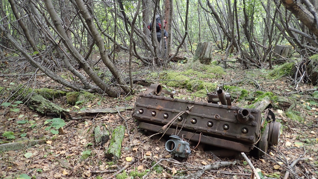
A little later, we started to see tree stumps, cut straight. We looked for signs of a cabin. Instead we found several old engine blocks, ceramic spark plugs still intact, and several old boards, nails protruding. We pondered what we had stumbled across. An old mine or lumber mill? 

A short while later we stepped onto the Nabesna Road, our trip almost complete. The path ahead was now obvious. The path of our trip had not been the one we had planned, but it was interesting, enjoyable, and relaxing. Soon we would be back in town, pursuing definded goals and meeting deadlines. But for a while, we had enjoyed a different kind of life, letting the path reveal itself. 

Ned celebrates reaching the Nabesna Road.