Saturday, July 27, 2024

Making New Friends on the Denali Highway


post by Corrine

Want to have a social weekend? Go solo bikepacking on the Denali Highway!

When I planned my recent trip, I hadn’t planned to meet new friends and touch base with an old friend, but that’s what happened. Traveling by bike can provide opportunities in a way that you can’t get in a motor vehicle. You travel more slowly. You don’t have metal and glass cutting you off from the natural world. And you are sharing an activity with other cyclists that makes for an immediate connection. 

And I still got some solo time on my bike, which is a great way to let my mind relax and wander. The weather, too, was phenomenal – with no haze or smoke – which made for incredible views. The weekend was perfect. Well, except for the no-see-ums, little biting gnats. I could have done without their company, but they were fairly easy to deal with.

Bike-Busy Denali Highway


This trip was spur-of-the-moment. Eric and I had just returned from a week in the Yukon but when I checked the forecast – which I do constantly – the weekend weather looked phenomenal for Interior Alaska. How could I stay home? Yes, I was tired and there were chores to do, but I also needed to keep training for my upcoming Arkansas High Country bikepacking race. Training should take precedence over mundane home chores, right? Eric had some volunteering commitments and chores he wanted to do, so he stayed home.

But where to go? I had done the bikepacking routes close to home. I wanted something different but couldn’t come up with a viable route. So, I decided on a reliable standard trip: the Denali Highway. I hadn’t biked there in a couple of years and with clear skies the views would be amazing.

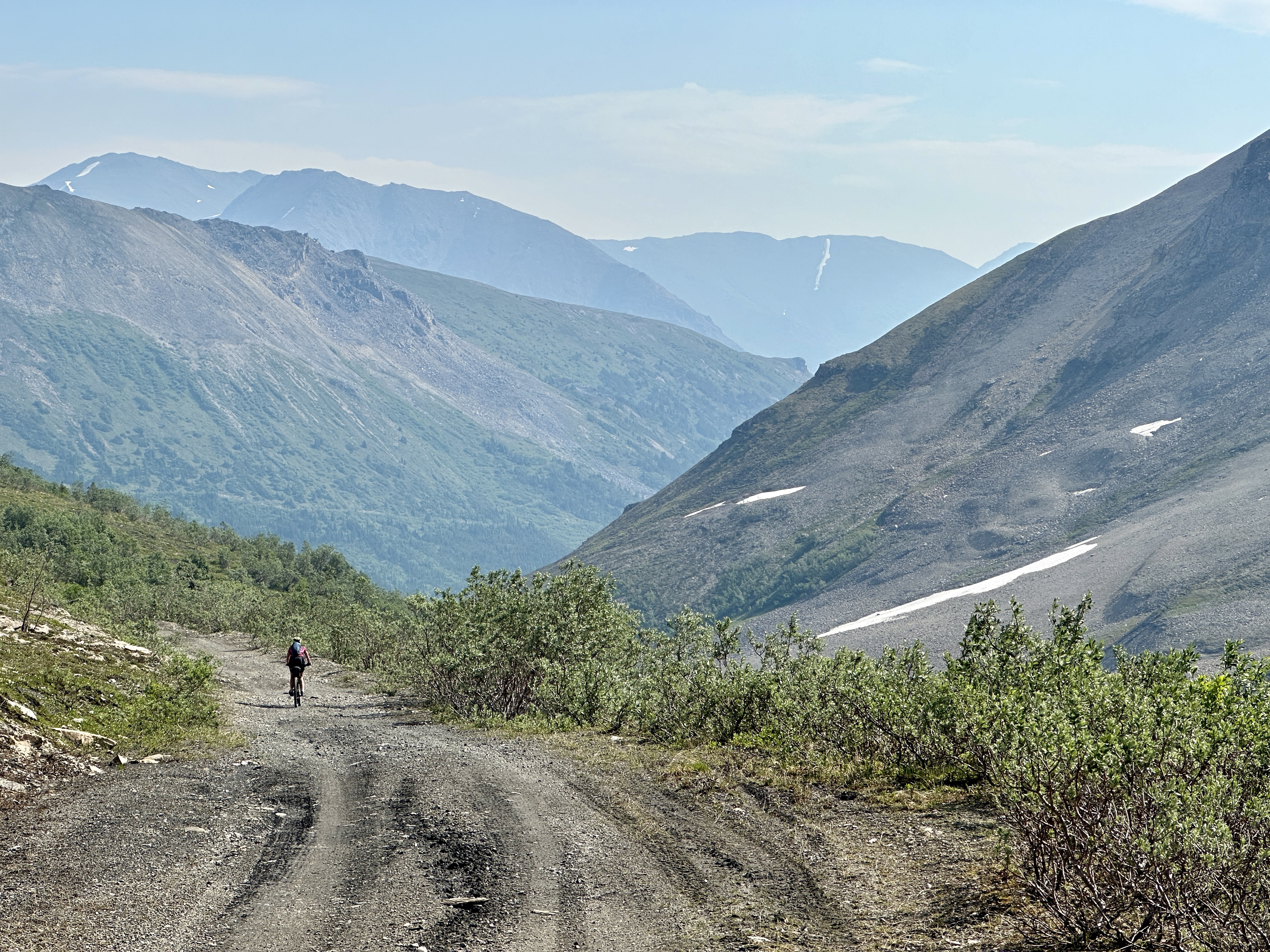
The Denali Highway is always a good choice for bikepacking

I got out of town around lunchtime on Friday with a goal of driving to Brushkana Creek Campground, about 30 miles in on the Denali Highway. After a night there, I would bike out the highway, camp, then bike back on Sunday and drive home.

Brushkana Creek

While driving on the Denali Highway, I passed several bikers and stopped to talk to some of them. They were part of group doing a three-day supported ride across the highway with Alaska Cycling Adventures. They had a sag wagon so didn’t have to carry much on their bikes. I also passed a fully loaded female bikepacker. 

After I set up my tent at Brushkana, the female bikepacker, Darlene, showed up. She was stopping to visit the volunteer campground hosts, whom she had met the day before while camping in Cantwell. A 30-something year old from San Diego, Darlene was doing a 1000-mile bike ride around Alaska. She had applied for the “Lael Rides Alaska” 2021 Femme-Trans-Women’s Scholarship. She didn’t win the scholarship but decided to come up this year and do her ride anyway. She had just finished a cold, rainy week in Denali National Park and was glad for nicer weather. 

Darlene with the campground hosts at Brushkana Creek Campground.  They all had interesting stories to share

I had a great time talking with her. Since I wasn’t on a schedule, I rode with her for a few miles to hear more of her story. We hit it off and shared a love of biking and going on adventures. She was excited to hear about my bikepack race experiences as it’s something she has considered. She kept calling me a “bad ass.” I just laughed. Maybe I should call myself the Bad-Assed Old Lady Biker! 

Darlene continues on her adventure

After six miles, I reluctantly headed back. Darlene was hoping to go another 30 miles to Alpine Creek Lodge or possibly 60 miles to McLaren River Lodge. After a week of camping in the rain, she wanted to stay inside. It seemed unlikely that we would see each other again, but I planned to leave on my bike early the next morning so I told her maybe I could catch her. She was carrying a lot more gear and moving slower than me. We exchanged information to keep in touch and then it was time to say good-by. 

After dinner, I hiked a little way out the Brushkana Creek Trail, a rough 4-wheeler trail that climbs up on a little plateau for good views of the Alaska Range. I hiked further than I had planned as my wanderlust was strong. But I finally turned around and headed back to the campground, finally getting to bed after 10:30 PM.

I ended up doing a 5-mile round trip hike down to the creek and an abandoned old cabin

Looking for Darlene


I started biking by 8 a.m. the next morning, bundled up. The night had been chilly (maybe down to 40F), but the day warmed quickly with the sun, and I was soon down to my shorts and jersey. I thought I might be able to catch Darlene. She had gotten on a late schedule. I guessed she didn’t get to Alpine Creek Lodge until after 10 PM and would have stopped there. Maybe she slept in and got a late start?


I passed the lodge at about 11 AM and briefly thought about seeing if Darlene was still there. But I guessed she had already started biking. Plus, the lodge has a long, steep driveway. Did I want to bike that just to find she was already gone? Instead, I kept riding, doing math in my head. I tried to figure out my average speed vs her possible average speed and based on different times that she might have left the lodge, how long it might take me to catch her (assuming she had even stayed there). Doing these story problems made the time pass quickly. All my calculations came out the same: there was no way I would catch her. Such is life.


Only a few vehicles drove by, so dust was minimal, and the riding was great. A few miles from McClaren River Lodge a young woman in an old Subaru going the other way yelled something to me. I yelled back and turned around to see what she had said. She stopped and said she was just telling me I was doing a great job going uphill. We talked for a bit. Constance had spent the last couple of nights at the McClaren River Lodge, exploring, packrafting, and having a great time. I asked if she had seen a solo female biker. She hadn’t, she had only seen a couple of bikers who were not carrying any gear.

Hmm, could Darlene still be behind me? I told Constance that if she saw Darlene, tell her I would see her that evening. I had already decided that I would camp near the road somewhere around McClaren Summit. I decided to keep my eye out for her. Then, since I was so close to McClaren River Lodge and I was hungry, I booked it there to get an afternoon meal of burger and fries. 


In the lodge, I saw the bikers that Constance had mentioned. They were a couple from Anchorage, exploring for the weekend. They had camped along the highway and were doing an out-and-back ride to the lodge for lunch. I mentioned Darlene, and they said they had seen her at the Alpine Creek Lodge that morning when they stopped for a snack. That had been before I passed the lodge. Dang! I should have stopped! The couple stayed at the lodge much longer than they expected while talking to her. We all agreed that she was an amazing woman doing a great trip. After eating, they were headed back to their vehicle, so would see her again. I told them to tell her that I would be waiting to see her along the road that evening. 

I ate lunch at the lodge and tried to pay for a meal for Darlene in advance with my credit card, but the lodge couldn’t make that happen. Oh well. After my late lunch, I biked the six-mile uphill grunt to the top of McClaren Summit. That was hard with a stomach stuffed full of burger and fries, so I stopped often for photos. I quickly realized the no-see-ums were atrocious! As long as I kept moving, I was fine. Good motivation!


After I topped out at the summit, I kept riding back and forth looking for the perfect place to camp. I really didn’t want to camp at a pullout right on the edge of the road. Several 4-wheeler trails take off from the road, but they lead into brush and more bugs. As I waffled, biking back and forth, I lost out on some okay sites to truck campers. Finally, I decided to drag my bike uphill from the road to a semi-flat spot on the tundra. There was a slight breeze there (which might keep down the bugs) and an awesome view of the lakes and the mountains. It looked like a great spot to set up camp. And I could keep an eye out for Darlene.

Not a bad campsite!

Just as I got the tent set up, I saw a biker coming from the east, so I yelled hello. He looked surprised to see a person with a bike on the tundra above the road. As I walked back down to the road we quickly realized we knew each other. Ryan is a friend from Fairbanks. He had also decided to get out of town and do a ride on the Denali Highway. He started at Paxson and was riding the 35 miles to McClaren River Lodge where he had booked a room. His ride had pretty much been uphill the whole time. He was hot and sweaty and annoyed with the gnats, so he didn’t stop long. I told him it was just a quick downhill to the lodge. I told him to look for Darlene and let her know I was up on the summit camping.


I had a snack but then I wasn’t sure what to do. It was only 6 PM, too early for bedtime but too buggy to relax in one place, so I decided to bike back towards the lodge looking for Darlene. I soon came upon a couple of the Alaska Cycling Adventures riders. They were teenagers and, although glad not to have loaded bikes, they were interested in hearing about being self-supported. They said they wanted to try it someday. They didn’t stop long as they were hungry, and dinner was being prepared for them just a few miles up the road. 

Teenagers that were part of the supported ride across the Denali Highway

I continued and just as I got to the McClaren Summit sign (which is BELOW the summit), I finally saw Darlene spinning slowly up the climb. Yay! Finally! I had started to worry that I wouldn’t see her again. 

Almost to the top of McClaren Summit and still smiling!

I biked with her a few miles and she told me how it seemed like everybody had stopped and told her I was looking for her. The lodge told her I had tried to buy her dinner. She said she felt like a celebrity! We had a great time chatting and biking together for another 15 minutes, but she had to book it to Meier’s Lake on the Richardson Highway, where she was spending the night – still 40 (mostly downhill) miles away. I needed to turn around, too. My legs were tired after 80 miles of riding. We were both happy to have seen each other again and promised to keep in touch. It is so special to meet like-minded people and spend time together. 

Another Day – More People, More Connections


I had a quiet night and got up early the next morning. The no-see-ums were out already and instead of enjoying their company while making oatmeal, I biked downhill for breakfast at the McClaren River Lodge. Tough choice! Just as I finished eating, Ryan showed up for breakfast. I lingered a bit longer than I should have talking to him. I had a long day ahead of me – I had to bike 65 more miles before my four-hour drive home – but I was willing to put it off for a while. 

Ryan joins me for breakfast at the McClaren Lodge

But finally, I said goodbye to Ryan. I got back on my bike, put in my earbuds, and listened to music to help me up the hills. My legs felt better than I expected, and it was still sunny and warm with beautiful views. The miles went by quickly.


A couple of hours later I turned off on a side spur for yet another expansive view of the Alaska Range. There was a car parked there, an old Subaru I remembered from the day before. “Constance!” I called out, startling her as she got out from her car. She had slept there the night before. We laughed about seeing each other again. I was able to tell her I had connected with Darlene the night before and then we enjoyed the view and took photos of each other. Another great human connection. 

Constance, another free spirit I met along the way.  She takes photos with her plastic dinosaurs in beautiful locations

A little later, as I biked up one of the last hills of my ride, I saw a bikepacker at the top. He was stopped, waiting for his wife. I ended up talking to Tim and his wife Cassie for close to an hour. Cassie had finished treatment for breast cancer the year before. They were on a three-month adventure, biking from Deadhorse back to their home in Missoula. 

Tim and Cassie, from Missoula, who are biking from Deadhorse back home to Montana

As we talked, we kept making connections. While in Fairbanks, they had stayed with friends of mine. And they had met Darlene while biking in Denali. (And after I got home and was telling Eric this story, he realized that this same couple had emailed him, in his role as Fairbanks Cycle Club president, about the logistics of cycling the Dalton Highway.) It’s a small world, at least when it comes to bikepacking. 


I gave them some intel on their route going forward and I got their Instagram info so I can follow their adventure as they make their way home. And they are going to send us some ideas for bikepacking routes around Missoula that Eric and I could do if we are in the area visiting our daughter, who lives in Missoula.

Being Social While Biking Solo


Finally, I had just a few more miles until reaching my car and making the long drive home. I thought about my weekend. I did a solo bikepacking trip, but I wasn’t alone. I had many interactions with interesting and fun people. I love being outdoors in spectacular settings. I love spending time alone. But I also love meeting other people with whom I share a passion. I spent only about an hour with every person I met this weekend, but I felt like I made a connection with each one. Human connection is what makes life interesting and worthwhile. And bikepacking is a great way to do that. 


Tuesday, July 16, 2024

The Spell of the Yukon


It’s the great, big, broad land ’way up yonder,

It’s the forests where silence has lease;

It’s the beauty that thrills me with wonder,

It’s the stillness that fills me with peace.

--The Spell of the Yukon by Robert Service

Post by Corrine

Despite being “next door” to Alaska, the Yukon is not a place Eric and I had spent much time. It had always been just a stop as we passed through on our way to or from another destination like Skagway or Haines or the Lower 48. But I just had a week off in early July. We had no Lower 48 trips planned and the weather on the Alaska road system was lousy. The weather forecast in the Yukon, however, looked good, especially down by Whitehorse. 


We started doing some research. Then we talked to friends who have a place in Whitehorse, and they started telling us about all the places we could explore. It all sounded intriguing. Eric and I decided it was time to find out about our neighbor to the east. Robert Service fell under its spell. Maybe we would, too.

We put together an ambitious itinerary including hiking, biking, and camping. There was no way we could do all the things we wanted to do in a week, but we could try. 

Exploring by Foot


Kluane National Park was on our definite to-do list. It’s the one place we have stopped for a hike or bike on our way to and from Alaska. We wanted to do something new, so we settled on the King’s Throne out of Kathleen Lake. It’s a 3-mile hike with a one-mile steep uphill to the “seat” of the “throne”, a chair-like cirque. The hike has an option to hike up a consistently steeper ridge all the way to the summit on the back of the “throne.” Trail guides said to plan 7-10 hours for that full round-trip hike. The weather was good, so of course we decided to go for the summit! 

Headed towards the King's Throne. We ended up hiking to the bowl then up the ridge on the left and across part of higher ridge line

This is one of the most popular day hikes in Kluane and there were dozens of people making the trek. We leap-frogged with a group of three hikers from Ontario in their early 30’s and they seemed impressed that we stayed ahead of them on the steep climb. I guess we are doing okay for a couple of gray-haired hikers. 

This challenging hike has rocky sections of trail as you approach the base of the cirque. While it has some switchbacks, there are several steep sections with loose rock. We were surprised so many people were willing to hike all the way to the base of the cirque.

Eric is almost at the cirque

Most people stop there. It’s a nice place for a snack or lunch break with great views and grassy patches. But the trail continues up, getting even steeper, with lots of loose rock, as it climbs the back of the rising edge of the cirque. We stopped only briefly at the cirque base before heading up. 


The going got harder and the wind got stronger. Once we got to a plateau on the ridge, the wind that had been brisk became fierce with gusts up to 50 mph that almost knocked me off my feet. And it was cold. We had layers but not enough. We went about another half-mile but turned back due to the wind and cold. Plus, clouds up top obscured the summit. We decided to leave that for another day.


The descent took longer than the ascent due to the steep and rocky trail. We were glad we had our trekking poles. Our quads were burning. And despite taking great care, we slipped several times, both of us falling at least once. Amazingly, quite a few people were climbing this part of the trail. Those Canadians are tough! We were glad to get to the relatively level couple miles of trail along Kathleen Lake back to the trailhead. 


The nine-mile roundtrip hike with 4000 feet of vertical elevation made for a longer than expected day. And we felt our quads for the next couple of days. But the views made up for it. This is a hike worth doing. 

Luckily, before the hike we had bought locally made cinnamon rolls in Haines Junction as a treat for after. (A bunch of places in the Yukon advertise their “world famous” cinnamon rolls. Who knew the Yukon was known for them! We tried two places, and they were great!) 

Back at Kathleen Lake, cinnamon rolls in hand, wind still blowing hard

A challenging hike with outstanding views, friendly people, and delicious cinnamon rolls afterward? The Yukon was already casting its spell on us!

Other Hikes


We didn’t end up doing any other big hikes, but we did do a couple of smaller hikes on our trip up the South Canol Road. We did a short hike on an overgrown path through bug-infested woods to reach the small but nice Ian Thomson Falls. At the northern end of South Canol Road we did another short hike for better views of the Lapie River Canyon. Neither is a destination hike, but both were worth doing since they were on our route.

Buggy hike to the falls

Ian Thomson Falls

Lapie River Canyon

Adventuring by Car – Part 1


Our big car adventure was to drive the South Canol Road, which was built by the U.S. military during WWII to build a pipeline (Canol = Canadian Oil) to help protect Alaska and the North American west coast. After the pipeline shut down the road gradually deteriorated. But it was reopened by the Canadian government to connect communities, encourage mining, and provide a place for outdoor adventures. 

The road connects Ross River and Johnson Crossing. Like the Denali Highway, the South Canol is open only in the summer, but unlike the Denali Highway, it is much rougher and narrower with no services along its 140-mile length. I had wanted to bike a portion of it, but my legs were tired from our big hike, and I had another big adventure planned for us along the route. 

Many signs along the road were overgrown by trees and brush

The drive was much slower than we expected, and it took us most of the day to get to our campsite at Lapie Lakes, very close to where our bike adventure would start. Just as we were getting to the lakes, we had a flat tire. Our Toyota RAV4 doesn’t have a full-size spare, so it would be another 30 miles of rough road to get to the small community of Ross River, with no guarantee of a fix there. But that was a problem for another day. We parked the car at a great lakeside campsite and prepared for our adventure the next day.

Oh no!

Not a bad campsite

Adventuring by Bike – Part 1


I had read about a couple who had done a hike off Ground Hog Creek mining road, which branches off South Canol Road near Lapie Lakes. The photos made it look enticing, so I planned for us to bike the mining road, which starts a mile or so from the campground, and possibly go for a hike at the high point. 

Smoke from nearby wildfires smudged the sky as we started biking, but otherwise the weather was great. We planned to bike to the mining road’s high point, maybe do a hike, then head down to Seagull Lake. The road started good but deteriorated the farther we got. We had to cross a couple of streams, which weren’t difficult, but I still got wet feet. 


We gradually climbed and kept thinking we were at the pass but then the road would climb some more. And some more. And some more. We finally got to the true summit above treeline with magnificent views of the surrounding mountains. By this time, the wildfire smoke was mostly gone. We could see old mining roads headed off in every direction that called for us to explore, but we decided to stick to the main road to Seagull Lake. We also decided to put off the hike until our return.

Yes, this truly is finally the high point!

Past the summit, the road headed down and got rockier and more rutted before plunging steeply for the last two miles to valley floor. The road keeps going for many miles, but a short side road  12 miles in took us to Seagull Lake. 

The going got steeper and steeper

We had a nice little lunch at the lake and then had a hot, hard grunt to push and ride our bikes back to the summit. It was totally worth the effort, and we had outstanding views to keep us motivated. But by the time we got back to the pass neither of us was motivated to hike up one of the surrounding peaks. It would be great to bikepack in here and then explore for several days. Another time. Instead, we bombed downhill back to the road and our campsite – after a quick detour for the hike to Ian Thomson Falls just off the South Canol. Another great day in the Yukon!

Seagull Lake

2 mile steep uphill push 

And a nice descent back to South Canol Rd.

Adventuring by Car – Part 2


The next day we packed up and limped north, hoping our spare tire would survive the rough road. Fortunately, our tire held up and we got it repaired in Faro. Then we headed back to Whitehorse.

That little trip ended up being a 460-mile driving loop: Whitehorse, east to Johnson’s Crossing (another place with “world famous” cinnamon rolls), north up the South Canol to Ross River, west to Carmacks, and back south to Whitehorse.

Whitehorse to Johnson's Crossing to Ross River to Carmacks and back.  Our campsite at Lapie Lakes was about 3/4 of the way up the S.Canol Road

Checking out the South Canol and Ground Hog Creek mining road added to the spell of the Yukon. It was a truly remote experience. If you go, I recommend either driving just the northern part of the road – which has better views and is in better shape – or, alternatively, biking some or all of it. And I would like to come back and bike the North Canol Road from Ross River to the border of the Yukon and Northwest Territories. That section is even more remote. Anybody interested?

Adventuring by Bike – Part 2


We spent a couple of days biking around Whitehorse. So many varied routes: gravel roads, ski trails, bike paths through town, and singletrack mountain biking of all levels. (Eric called the Trail Forks map of trails “fun spaghetti.”) We needed several more days to check it all out. 

Our first day in town before the South Canol trip, we explored singletrack trails along the Yukon River and up to lower Grey Mountain. Eric enjoyed the technical challenges, but I got tired of the narrow, rooty trails with steep drop-offs to rivers or lakes. We finally popped out onto the Grey Mountain Road. 


Yep, the trail goes up this rocky part

Eric suggested that we bike the gravel road up to a set of towers high on the mountain. I was a little surprised as he normally doesn’t like long uphill grinds on gravel roads, but I love those kinds of rides. It was a warm day, and Eric started regretting his suggestion as the road climbed steeper and steeper, but we eventually both made it to the towers and were glad we did it as the views down to the Yukon River and Whitehorse were outstanding. And the descent was fun and nontechnical. I even managed to get second overall on Strava for the descent. Those of you that know how much of a weenie I am on descending will be as surprised as I am about that!

We make it to the top of Grey Mountain!

Super fun descent!

After our South Canol trip, Eric and I each did our own thing for a day in Whitehorse. Eric had a fabulous time exploring the singletrack trails on Mount McIntyre. He enjoyed the technical trails and the great views along many of them.

A rougher section of the Mount MacIntyre trails

A nicer section of the Mount MacIntyre trails

After all the technical riding around lower Grey Mountain, I wanted to bike some gravel roads. I did a 50-mile loop, climbing up to Fish Lake and then down to Jackson Lake before heading across Copper Haul Road back to town. I did make the mistake of trying to take a ski trail over to the trails where Eric was biking, only to end up in a swamp. Eric is the one who loves swamps, not me! After getting wet and muddy feet, I finally turned around to make my way back by roads. 

Fish Lake

On the trail before the swamp, I did have a fairly close encounter with a black bear. He was easily scared off, so I didn’t have to turn around. But come to think of it, if I had turned around, I would not have ended up in the swamp! 

Black bear on the trail


Eric thought most of the singletrack trails on Mount McIntyre were too technical for me, but he did feel that I would enjoy biking on the ski trails. So, on our final morning in Whitehorse we spent a couple of hours exploring them before heading home. The spell was working as we started talking about coming back in winter to ski the many kilometers of groomed trails. 

Ski hut along the ski trail. Such a great idea!


Camping


We car camped four of eight nights, spending time in national park and territorial park campgrounds. At Congdon Creek Campground on Kluane Lake, all tent campers had to be within an electric bear-deterrent fence. On our drive down the Alaska Highway, we saw five bears along the road before getting to this campground, so it was reassuring to have that protection. 

Close up bear seen from the safety of our car along the Alaska Highway

Our favorite campground was the minimalist Lapie Lakes along the South Canol Road. It was remote and had only two spots. When we arrived, the best spot was already taken, but the other was fine. We met the other campers, Dwayne and Glenda, who are from outside of Edmonton. They love this spot for its remoteness, lack of people, beauty, and good fishing (Dwayne is an avid fisherman). They invited us for a fresh trout dinner the next night after we told them about our plans of biking Ground Hog Creek mining road to Seagull Lake. Hmm, fresh trout or freeze-dried dinners. Decisions, decisions! 

Campsite at Lapie Lakes

We had an excellent dinner and the conversation flowed as we talked for hours. They told us about once having driven their truck camper, while towing their boat, down to Seagull Lake. Glenda told us she was terrified during the steeper parts of the drive. And after pushing our bikes up the steep, rutted road, we were amazed they had made it there and back without mishap! 

Dwayne and Glenda serve us an extremely tasty fresh lake trout dinner

They told us that their community outside of Edmonton holds the Canadian Birkebeiner in February. We are planning to ski the American Birkebeiner in 2025 (fourth time’s the charm?), but we had no idea there was a Canadian version, which attracts around 1,500 people yearly. We may have to put that on our bucket list to do in the future. 

The Spell of the Yukon

After seven days, we had to drive back home, camping one more time along the way. It was an amazing trip. We had great weather with sunny skies, minimal rain, only one day with a little smoke, and almost no mosquitoes. Everyone was super friendly. (And we even ran into several Fairbanksans on the trip!)

And there’s still so much to do. For example, we want to return and go backpacking in Tombstone Territorial Park northeast of Dawson. And we want to visit Whitehorse in winter to explore their ski trails. And there’s the Cottonwood Trail and North Canol Road and trails in Carcross and…. So, we will be back. We, too, have fallen under the spell of the Yukon.

The summer—no sweeter was ever;

The sunshiny woods all athrill;

The grayling aleap in the river,

The bighorn asleep on the hill.

The strong life that never knows harness;

The wilds where the caribou call;

The freshness, the freedom, the farness—

O God! how I’m stuck on it all.